You are here: Home > Network List > AZ - ANZA Regional Network Stations List
> Station SMER AZ.SMER > Earthquake Result Viewer
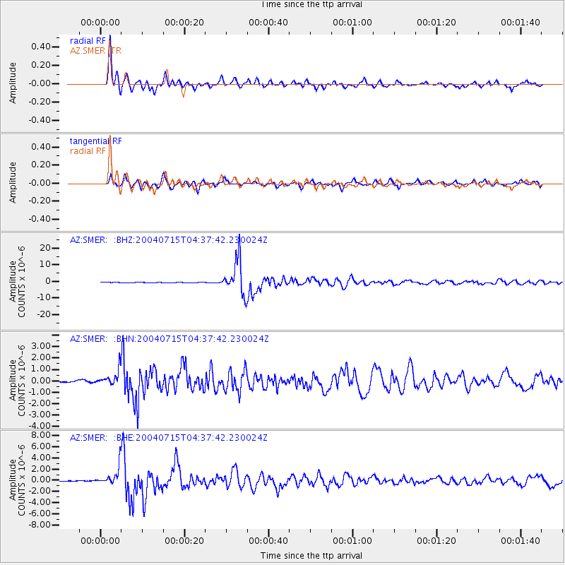
SMER AZ.SMER - Earthquake Result Viewer
*The percent match for this event was below the threshold and hence no stack was calculated.
| Earthquake location: |
Fiji Islands Region |
| Earthquake latitude/longitude: |
-17.6/-178.6 |
| Earthquake time(UTC): |
2004/07/15 (197) 04:27:12 GMT |
| Earthquake Depth: |
560 km |
| Earthquake Magnitude: |
5.5 MB |
| Earthquake Catalog/Contributor: |
WHDF/NEIC |
|
| Network: |
AZ ANZA Regional Network |
| Station: |
SMER AZ.SMER |
| Lat/Lon: |
33.46 N/117.17 W |
| Elevation: |
355 m |
|
| Distance: |
77.5 deg |
| Az: |
48.767 deg |
| Baz: |
239.071 deg |
| Ray Param: |
$rayparam |
*The percent match for this event was below the threshold and hence was not used in the summary stack. |
|
| Radial Match: |
95.5712 % |
| Radial Bump: |
400 |
| Transverse Match: |
90.72552 % |
| Transverse Bump: |
400 |
| SOD ConfigId: |
2459 |
| Insert Time: |
2010-02-26 20:49:07.359 +0000 |
| GWidth: |
2.5 |
| Max Bumps: |
400 |
| Tol: |
0.001 |
|
Signal To Noise
| Channel | StoN | STA | LTA |
| AZ:SMER: :BHN:20040715T04:37:42.230024Z | 4.539869 | 7.735924E-7 | 1.7039972E-7 |
| AZ:SMER: :BHE:20040715T04:37:42.230024Z | 29.532984 | 1.7604465E-6 | 5.9609505E-8 |
| AZ:SMER: :BHZ:20040715T04:37:42.230024Z | 54.585648 | 5.227285E-6 | 9.576299E-8 |
| Arrivals |
| Ps | |
| PpPs | |
| PsPs/PpSs | |


