You are here: Home > Network List > MN - MEDNET Project Stations List
> Station TIP Timpagrande, Italy > Earthquake Result Viewer
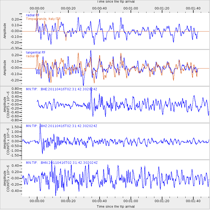
TIP Timpagrande, Italy - Earthquake Result Viewer
*The percent match for this event was below the threshold and hence no stack was calculated.
| Earthquake location: |
Eastern Honshu, Japan |
| Earthquake latitude/longitude: |
36.4/139.7 |
| Earthquake time(UTC): |
2011/04/16 (106) 02:19:30 GMT |
| Earthquake Depth: |
77 km |
| Earthquake Magnitude: |
5.9 MB, 5.8 MW, 5.8 MW |
| Earthquake Catalog/Contributor: |
WHDF/NEIC |
|
| Network: |
MN MEDNET Project |
| Station: |
TIP Timpagrande, Italy |
| Lat/Lon: |
39.18 N/16.76 E |
| Elevation: |
789 m |
|
| Distance: |
88.2 deg |
| Az: |
319.236 deg |
| Baz: |
42.684 deg |
| Ray Param: |
$rayparam |
*The percent match for this event was below the threshold and hence was not used in the summary stack. |
|
| Radial Match: |
71.89699 % |
| Radial Bump: |
400 |
| Transverse Match: |
61.60312 % |
| Transverse Bump: |
400 |
| SOD ConfigId: |
356183 |
| Insert Time: |
2011-09-30 04:28:43.342 +0000 |
| GWidth: |
2.5 |
| Max Bumps: |
400 |
| Tol: |
0.001 |
|
Signal To Noise
| Channel | StoN | STA | LTA |
| MN:TIP: :BHZ:20110416T02:31:42.302024Z | 6.693459 | 6.677374E-7 | 9.9759696E-8 |
| MN:TIP: :BHN:20110416T02:31:42.302024Z | 1.9987693 | 1.5477876E-7 | 7.743703E-8 |
| MN:TIP: :BHE:20110416T02:31:42.302024Z | 2.1272457 | 2.4594647E-7 | 1.15617325E-7 |
| Arrivals |
| Ps | |
| PpPs | |
| PsPs/PpSs | |


