You are here: Home > Network List > TA - USArray Transportable Network (new EarthScope stations) Stations List
> Station T25A Trinidad, CO, USA > Earthquake Result Viewer
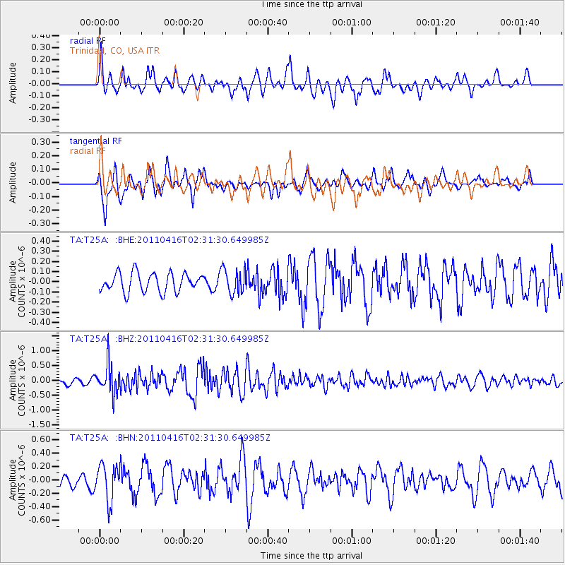
T25A Trinidad, CO, USA - Earthquake Result Viewer
*The percent match for this event was below the threshold and hence no stack was calculated.
| Earthquake location: |
Eastern Honshu, Japan |
| Earthquake latitude/longitude: |
36.4/139.7 |
| Earthquake time(UTC): |
2011/04/16 (106) 02:19:30 GMT |
| Earthquake Depth: |
77 km |
| Earthquake Magnitude: |
5.9 MB, 5.8 MW, 5.8 MW |
| Earthquake Catalog/Contributor: |
WHDF/NEIC |
|
| Network: |
TA USArray Transportable Network (new EarthScope stations) |
| Station: |
T25A Trinidad, CO, USA |
| Lat/Lon: |
37.14 N/104.41 W |
| Elevation: |
2017 m |
|
| Distance: |
85.8 deg |
| Az: |
46.1 deg |
| Baz: |
313.308 deg |
| Ray Param: |
$rayparam |
*The percent match for this event was below the threshold and hence was not used in the summary stack. |
|
| Radial Match: |
66.31683 % |
| Radial Bump: |
400 |
| Transverse Match: |
63.737606 % |
| Transverse Bump: |
377 |
| SOD ConfigId: |
356183 |
| Insert Time: |
2011-09-30 04:38:59.986 +0000 |
| GWidth: |
2.5 |
| Max Bumps: |
400 |
| Tol: |
0.001 |
|
Signal To Noise
| Channel | StoN | STA | LTA |
| TA:T25A: :BHZ:20110416T02:31:30.649985Z | 8.563961 | 5.059232E-7 | 5.907584E-8 |
| TA:T25A: :BHN:20110416T02:31:30.649985Z | 3.662888 | 2.7472393E-7 | 7.5002E-8 |
| TA:T25A: :BHE:20110416T02:31:30.649985Z | 1.3093293 | 1.2096143E-7 | 9.238427E-8 |
| Arrivals |
| Ps | |
| PpPs | |
| PsPs/PpSs | |


