You are here: Home > Network List > TA - USArray Transportable Network (new EarthScope stations) Stations List
> Station H25A Fruitdale, SD, USA > Earthquake Result Viewer
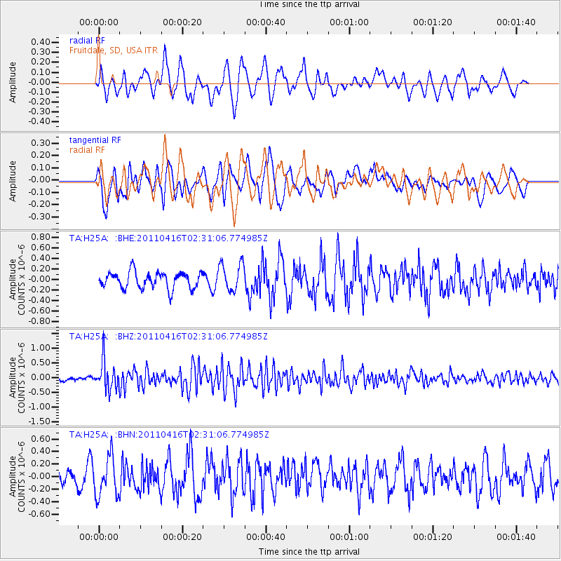
H25A Fruitdale, SD, USA - Earthquake Result Viewer
*The percent match for this event was below the threshold and hence no stack was calculated.
| Earthquake location: |
Eastern Honshu, Japan |
| Earthquake latitude/longitude: |
36.4/139.7 |
| Earthquake time(UTC): |
2011/04/16 (106) 02:19:30 GMT |
| Earthquake Depth: |
77 km |
| Earthquake Magnitude: |
5.9 MB, 5.8 MW, 5.8 MW |
| Earthquake Catalog/Contributor: |
WHDF/NEIC |
|
| Network: |
TA USArray Transportable Network (new EarthScope stations) |
| Station: |
H25A Fruitdale, SD, USA |
| Lat/Lon: |
44.62 N/103.60 W |
| Elevation: |
942 m |
|
| Distance: |
81.1 deg |
| Az: |
40.195 deg |
| Baz: |
313.167 deg |
| Ray Param: |
$rayparam |
*The percent match for this event was below the threshold and hence was not used in the summary stack. |
|
| Radial Match: |
65.49917 % |
| Radial Bump: |
400 |
| Transverse Match: |
56.090992 % |
| Transverse Bump: |
400 |
| SOD ConfigId: |
356183 |
| Insert Time: |
2011-09-30 04:45:45.003 +0000 |
| GWidth: |
2.5 |
| Max Bumps: |
400 |
| Tol: |
0.001 |
|
Signal To Noise
| Channel | StoN | STA | LTA |
| TA:H25A: :BHZ:20110416T02:31:06.774985Z | 4.364561 | 4.937584E-7 | 1.13129E-7 |
| TA:H25A: :BHN:20110416T02:31:06.774985Z | 1.71407 | 3.2522397E-7 | 1.8973785E-7 |
| TA:H25A: :BHE:20110416T02:31:06.774985Z | 1.7460587 | 2.6820837E-7 | 1.5360787E-7 |
| Arrivals |
| Ps | |
| PpPs | |
| PsPs/PpSs | |


