You are here: Home > Network List > AZ - ANZA Regional Network Stations List
> Station SMER AZ.SMER > Earthquake Result Viewer
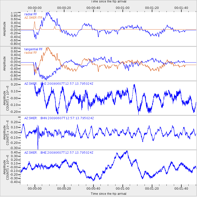
SMER AZ.SMER - Earthquake Result Viewer
*The percent match for this event was below the threshold and hence no stack was calculated.
| Earthquake location: |
South Of Fiji Islands |
| Earthquake latitude/longitude: |
-22.0/-179.6 |
| Earthquake time(UTC): |
2009/06/07 (158) 12:46:30 GMT |
| Earthquake Depth: |
590 km |
| Earthquake Magnitude: |
5.5 MW, 5.1 MB |
| Earthquake Catalog/Contributor: |
WHDF/NEIC |
|
| Network: |
AZ ANZA Regional Network |
| Station: |
SMER AZ.SMER |
| Lat/Lon: |
33.46 N/117.17 W |
| Elevation: |
355 m |
|
| Distance: |
81.1 deg |
| Az: |
48.586 deg |
| Baz: |
236.337 deg |
| Ray Param: |
$rayparam |
*The percent match for this event was below the threshold and hence was not used in the summary stack. |
|
| Radial Match: |
55.70523 % |
| Radial Bump: |
400 |
| Transverse Match: |
64.96586 % |
| Transverse Bump: |
400 |
| SOD ConfigId: |
2648 |
| Insert Time: |
2010-02-26 20:49:18.187 +0000 |
| GWidth: |
2.5 |
| Max Bumps: |
400 |
| Tol: |
0.001 |
|
Signal To Noise
| Channel | StoN | STA | LTA |
| AZ:SMER: :BHN:20090607T12:57:13.795024Z | 1.3553424 | 9.18982E-8 | 6.7804415E-8 |
| AZ:SMER: :BHE:20090607T12:57:13.795024Z | 1.5751144 | 1.03158E-7 | 6.549239E-8 |
| AZ:SMER: :BHZ:20090607T12:57:13.795024Z | 0.56632113 | 6.337416E-8 | 1.1190499E-7 |
| Arrivals |
| Ps | |
| PpPs | |
| PsPs/PpSs | |


