You are here: Home > Network List > AZ - ANZA Regional Network Stations List
> Station SMER AZ.SMER > Earthquake Result Viewer
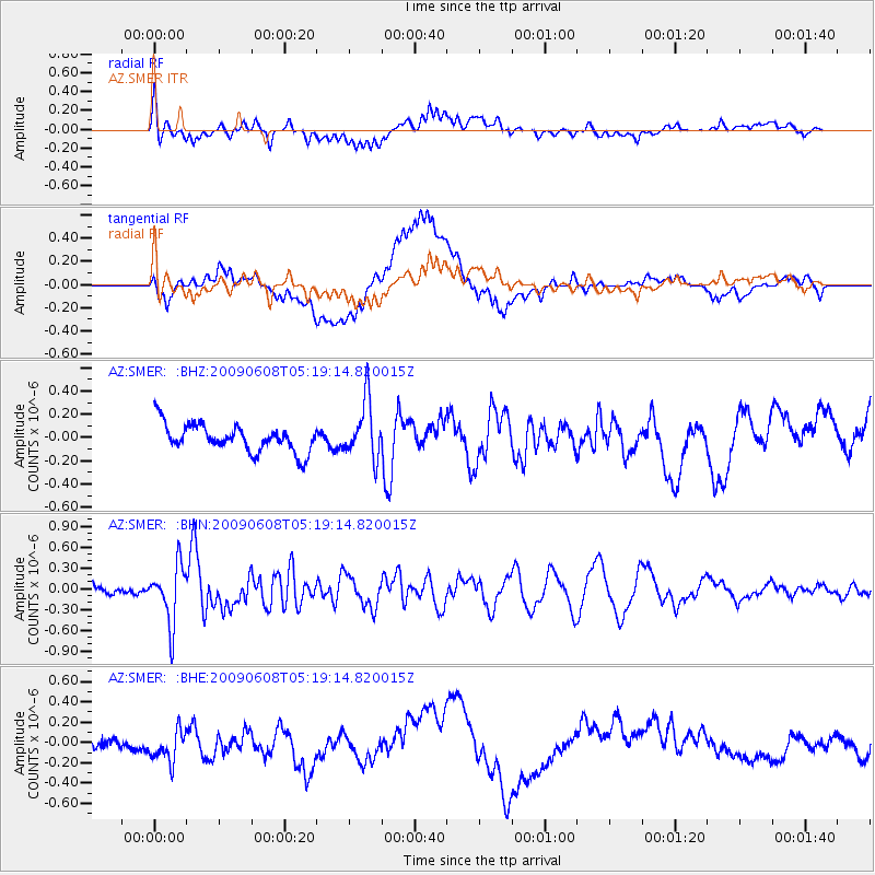
SMER AZ.SMER - Earthquake Result Viewer
*The percent match for this event was below the threshold and hence no stack was calculated.
| Earthquake location: |
Honduras |
| Earthquake latitude/longitude: |
15.8/-86.9 |
| Earthquake time(UTC): |
2009/06/08 (159) 05:13:14 GMT |
| Earthquake Depth: |
10 km |
| Earthquake Magnitude: |
5.5 MB, 4.9 MS, 5.4 MW, 5.4 MW |
| Earthquake Catalog/Contributor: |
WHDF/NEIC |
|
| Network: |
AZ ANZA Regional Network |
| Station: |
SMER AZ.SMER |
| Lat/Lon: |
33.46 N/117.17 W |
| Elevation: |
355 m |
|
| Distance: |
32.5 deg |
| Az: |
308.294 deg |
| Baz: |
115.335 deg |
| Ray Param: |
$rayparam |
*The percent match for this event was below the threshold and hence was not used in the summary stack. |
|
| Radial Match: |
52.53302 % |
| Radial Bump: |
400 |
| Transverse Match: |
54.578403 % |
| Transverse Bump: |
400 |
| SOD ConfigId: |
2648 |
| Insert Time: |
2010-02-26 20:49:21.645 +0000 |
| GWidth: |
2.5 |
| Max Bumps: |
400 |
| Tol: |
0.001 |
|
Signal To Noise
| Channel | StoN | STA | LTA |
| AZ:SMER: :BHN:20090608T05:19:14.820015Z | 6.838457 | 4.14372E-7 | 6.0594374E-8 |
| AZ:SMER: :BHE:20090608T05:19:14.820015Z | 1.5159543 | 2.2605532E-7 | 1.4911751E-7 |
| AZ:SMER: :BHZ:20090608T05:19:14.820015Z | 2.101549 | 2.4652624E-7 | 1.1730692E-7 |
| Arrivals |
| Ps | |
| PpPs | |
| PsPs/PpSs | |


