You are here: Home > Network List > TA - USArray Transportable Network (new EarthScope stations) Stations List
> Station 436A Wall Ranch, Gause, TX, USA > Earthquake Result Viewer
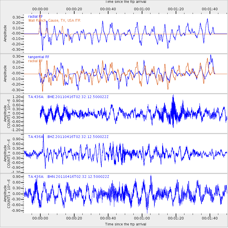
436A Wall Ranch, Gause, TX, USA - Earthquake Result Viewer
*The percent match for this event was below the threshold and hence no stack was calculated.
| Earthquake location: |
Eastern Honshu, Japan |
| Earthquake latitude/longitude: |
36.4/139.7 |
| Earthquake time(UTC): |
2011/04/16 (106) 02:19:30 GMT |
| Earthquake Depth: |
77 km |
| Earthquake Magnitude: |
5.9 MB, 5.8 MW, 5.8 MW |
| Earthquake Catalog/Contributor: |
WHDF/NEIC |
|
| Network: |
TA USArray Transportable Network (new EarthScope stations) |
| Station: |
436A Wall Ranch, Gause, TX, USA |
| Lat/Lon: |
30.77 N/96.80 W |
| Elevation: |
109 m |
|
| Distance: |
94.8 deg |
| Az: |
46.04 deg |
| Baz: |
317.553 deg |
| Ray Param: |
$rayparam |
*The percent match for this event was below the threshold and hence was not used in the summary stack. |
|
| Radial Match: |
39.286438 % |
| Radial Bump: |
387 |
| Transverse Match: |
41.115692 % |
| Transverse Bump: |
276 |
| SOD ConfigId: |
356183 |
| Insert Time: |
2011-09-30 05:13:21.561 +0000 |
| GWidth: |
2.5 |
| Max Bumps: |
400 |
| Tol: |
0.001 |
|
Signal To Noise
| Channel | StoN | STA | LTA |
| TA:436A: :BHZ:20110416T02:32:12.500022Z | 2.618191 | 3.803978E-7 | 1.4529031E-7 |
| TA:436A: :BHN:20110416T02:32:12.500022Z | 1.6676944 | 3.8993872E-7 | 2.3381905E-7 |
| TA:436A: :BHE:20110416T02:32:12.500022Z | 0.5168751 | 1.4421902E-7 | 2.7902104E-7 |
| Arrivals |
| Ps | |
| PpPs | |
| PsPs/PpSs | |


