You are here: Home > Network List > TA - USArray Transportable Network (new EarthScope stations) Stations List
> Station K32A Verdigre, NE, USA > Earthquake Result Viewer
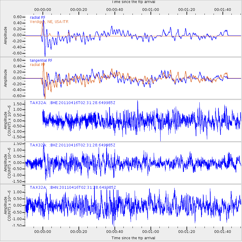
K32A Verdigre, NE, USA - Earthquake Result Viewer
*The percent match for this event was below the threshold and hence no stack was calculated.
| Earthquake location: |
Eastern Honshu, Japan |
| Earthquake latitude/longitude: |
36.4/139.7 |
| Earthquake time(UTC): |
2011/04/16 (106) 02:19:30 GMT |
| Earthquake Depth: |
77 km |
| Earthquake Magnitude: |
5.9 MB, 5.8 MW, 5.8 MW |
| Earthquake Catalog/Contributor: |
WHDF/NEIC |
|
| Network: |
TA USArray Transportable Network (new EarthScope stations) |
| Station: |
K32A Verdigre, NE, USA |
| Lat/Lon: |
42.66 N/97.97 W |
| Elevation: |
512 m |
|
| Distance: |
85.4 deg |
| Az: |
38.682 deg |
| Baz: |
316.861 deg |
| Ray Param: |
$rayparam |
*The percent match for this event was below the threshold and hence was not used in the summary stack. |
|
| Radial Match: |
59.281193 % |
| Radial Bump: |
400 |
| Transverse Match: |
54.317455 % |
| Transverse Bump: |
400 |
| SOD ConfigId: |
356183 |
| Insert Time: |
2011-09-30 05:27:18.031 +0000 |
| GWidth: |
2.5 |
| Max Bumps: |
400 |
| Tol: |
0.001 |
|
Signal To Noise
| Channel | StoN | STA | LTA |
| TA:K32A: :BHZ:20110416T02:31:28.649985Z | 3.2731082 | 6.3835614E-7 | 1.9503057E-7 |
| TA:K32A: :BHN:20110416T02:31:28.649985Z | 1.4986796 | 4.3894138E-7 | 2.928854E-7 |
| TA:K32A: :BHE:20110416T02:31:28.649985Z | 1.0977843 | 3.659117E-7 | 3.333184E-7 |
| Arrivals |
| Ps | |
| PpPs | |
| PsPs/PpSs | |


