You are here: Home > Network List > TA - USArray Transportable Network (new EarthScope stations) Stations List
> Station J31A Geddes, SD, USA > Earthquake Result Viewer
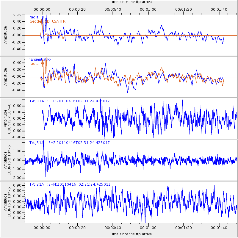
J31A Geddes, SD, USA - Earthquake Result Viewer
*The percent match for this event was below the threshold and hence no stack was calculated.
| Earthquake location: |
Eastern Honshu, Japan |
| Earthquake latitude/longitude: |
36.4/139.7 |
| Earthquake time(UTC): |
2011/04/16 (106) 02:19:30 GMT |
| Earthquake Depth: |
77 km |
| Earthquake Magnitude: |
5.9 MB, 5.8 MW, 5.8 MW |
| Earthquake Catalog/Contributor: |
WHDF/NEIC |
|
| Network: |
TA USArray Transportable Network (new EarthScope stations) |
| Station: |
J31A Geddes, SD, USA |
| Lat/Lon: |
43.29 N/98.74 W |
| Elevation: |
491 m |
|
| Distance: |
84.6 deg |
| Az: |
38.657 deg |
| Baz: |
316.338 deg |
| Ray Param: |
$rayparam |
*The percent match for this event was below the threshold and hence was not used in the summary stack. |
|
| Radial Match: |
55.309742 % |
| Radial Bump: |
400 |
| Transverse Match: |
68.578316 % |
| Transverse Bump: |
400 |
| SOD ConfigId: |
356183 |
| Insert Time: |
2011-09-30 05:31:42.618 +0000 |
| GWidth: |
2.5 |
| Max Bumps: |
400 |
| Tol: |
0.001 |
|
Signal To Noise
| Channel | StoN | STA | LTA |
| TA:J31A: :BHZ:20110416T02:31:24.42501Z | 4.4946074 | 7.8059946E-7 | 1.7367466E-7 |
| TA:J31A: :BHN:20110416T02:31:24.42501Z | 1.3414482 | 3.5107692E-7 | 2.6171486E-7 |
| TA:J31A: :BHE:20110416T02:31:24.42501Z | 1.4869064 | 3.9730097E-7 | 2.671997E-7 |
| Arrivals |
| Ps | |
| PpPs | |
| PsPs/PpSs | |


