You are here: Home > Network List > AZ - ANZA Regional Network Stations List
> Station SMER AZ.SMER > Earthquake Result Viewer
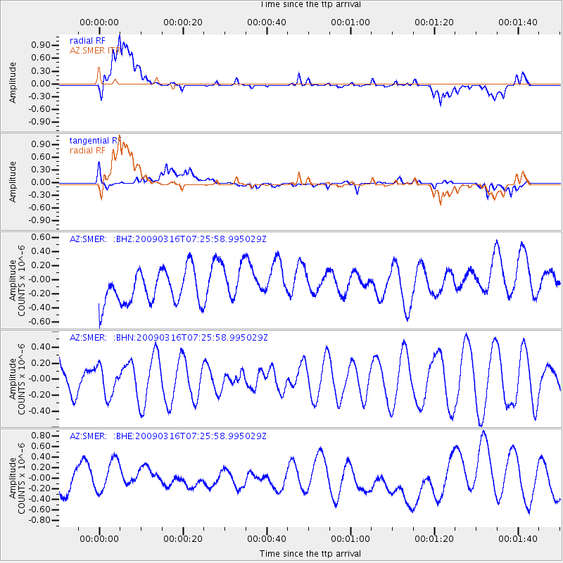
SMER AZ.SMER - Earthquake Result Viewer
*The percent match for this event was below the threshold and hence no stack was calculated.
| Earthquake location: |
Pacific-Antarctic Ridge |
| Earthquake latitude/longitude: |
-55.1/-129.7 |
| Earthquake time(UTC): |
2009/03/16 (075) 07:13:36 GMT |
| Earthquake Depth: |
10 km |
| Earthquake Magnitude: |
5.9 MW, 5.2 MS, 5.1 MB, 5.9 MW |
| Earthquake Catalog/Contributor: |
WHDF/NEIC |
|
| Network: |
AZ ANZA Regional Network |
| Station: |
SMER AZ.SMER |
| Lat/Lon: |
33.46 N/117.17 W |
| Elevation: |
355 m |
|
| Distance: |
88.9 deg |
| Az: |
10.451 deg |
| Baz: |
187.156 deg |
| Ray Param: |
$rayparam |
*The percent match for this event was below the threshold and hence was not used in the summary stack. |
|
| Radial Match: |
68.8953 % |
| Radial Bump: |
400 |
| Transverse Match: |
61.924995 % |
| Transverse Bump: |
400 |
| SOD ConfigId: |
2658 |
| Insert Time: |
2010-02-26 20:49:31.473 +0000 |
| GWidth: |
2.5 |
| Max Bumps: |
400 |
| Tol: |
0.001 |
|
Signal To Noise
| Channel | StoN | STA | LTA |
| AZ:SMER: :BHN:20090316T07:25:58.995029Z | 0.625775 | 1.8269974E-7 | 2.9195758E-7 |
| AZ:SMER: :BHE:20090316T07:25:58.995029Z | 1.1059842 | 4.0007598E-7 | 3.617375E-7 |
| AZ:SMER: :BHZ:20090316T07:25:58.995029Z | 1.1981574 | 2.7621718E-7 | 2.3053498E-7 |
| Arrivals |
| Ps | |
| PpPs | |
| PsPs/PpSs | |


