You are here: Home > Network List > CI - Caltech Regional Seismic Network Stations List
> Station MPP McPhearson Peak > Earthquake Result Viewer
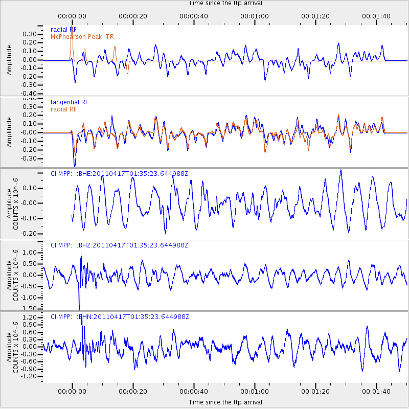
MPP McPhearson Peak - Earthquake Result Viewer
*The percent match for this event was below the threshold and hence no stack was calculated.
| Earthquake location: |
Santiago Del Estero Prov., Arg. |
| Earthquake latitude/longitude: |
-27.6/-63.2 |
| Earthquake time(UTC): |
2011/04/17 (107) 01:24:33 GMT |
| Earthquake Depth: |
563 km |
| Earthquake Magnitude: |
5.6 MD, 5.1 MB |
| Earthquake Catalog/Contributor: |
WHDF/NEIC |
|
| Network: |
CI Caltech Regional Seismic Network |
| Station: |
MPP McPhearson Peak |
| Lat/Lon: |
34.89 N/119.81 W |
| Elevation: |
1739 m |
|
| Distance: |
82.0 deg |
| Az: |
316.117 deg |
| Baz: |
131.563 deg |
| Ray Param: |
$rayparam |
*The percent match for this event was below the threshold and hence was not used in the summary stack. |
|
| Radial Match: |
58.871113 % |
| Radial Bump: |
400 |
| Transverse Match: |
60.24705 % |
| Transverse Bump: |
400 |
| SOD ConfigId: |
356183 |
| Insert Time: |
2011-09-30 06:34:22.271 +0000 |
| GWidth: |
2.5 |
| Max Bumps: |
400 |
| Tol: |
0.001 |
|
Signal To Noise
| Channel | StoN | STA | LTA |
| CI:MPP: :BHZ:20110417T01:35:23.644988Z | 1.7863494 | 4.94477E-7 | 2.7680866E-7 |
| CI:MPP: :BHN:20110417T01:35:23.644988Z | 1.8864893 | 4.430149E-7 | 2.3483562E-7 |
| CI:MPP: :BHE:20110417T01:35:23.644988Z | 1.0754594 | 1.0521062E-7 | 9.782854E-8 |
| Arrivals |
| Ps | |
| PpPs | |
| PsPs/PpSs | |


