You are here: Home > Network List > TA - USArray Transportable Network (new EarthScope stations) Stations List
> Station SFIN Lafayette, IN, USA > Earthquake Result Viewer
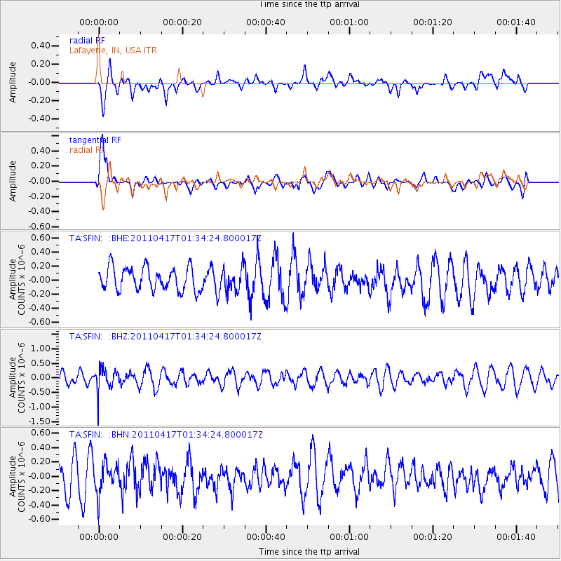
SFIN Lafayette, IN, USA - Earthquake Result Viewer
*The percent match for this event was below the threshold and hence no stack was calculated.
| Earthquake location: |
Santiago Del Estero Prov., Arg. |
| Earthquake latitude/longitude: |
-27.6/-63.2 |
| Earthquake time(UTC): |
2011/04/17 (107) 01:24:33 GMT |
| Earthquake Depth: |
563 km |
| Earthquake Magnitude: |
5.6 MD, 5.1 MB |
| Earthquake Catalog/Contributor: |
WHDF/NEIC |
|
| Network: |
TA USArray Transportable Network (new EarthScope stations) |
| Station: |
SFIN Lafayette, IN, USA |
| Lat/Lon: |
40.38 N/87.10 W |
| Elevation: |
165 m |
|
| Distance: |
71.2 deg |
| Az: |
340.913 deg |
| Baz: |
157.676 deg |
| Ray Param: |
$rayparam |
*The percent match for this event was below the threshold and hence was not used in the summary stack. |
|
| Radial Match: |
64.30957 % |
| Radial Bump: |
400 |
| Transverse Match: |
60.193287 % |
| Transverse Bump: |
400 |
| SOD ConfigId: |
356183 |
| Insert Time: |
2011-09-30 06:54:04.317 +0000 |
| GWidth: |
2.5 |
| Max Bumps: |
400 |
| Tol: |
0.001 |
|
Signal To Noise
| Channel | StoN | STA | LTA |
| TA:SFIN: :BHZ:20110417T01:34:24.800017Z | 1.5905926 | 3.9775048E-7 | 2.5006432E-7 |
| TA:SFIN: :BHN:20110417T01:34:24.800017Z | 0.72833025 | 2.0565355E-7 | 2.8236303E-7 |
| TA:SFIN: :BHE:20110417T01:34:24.800017Z | 0.9841285 | 1.6060112E-7 | 1.6319122E-7 |
| Arrivals |
| Ps | |
| PpPs | |
| PsPs/PpSs | |


