You are here: Home > Network List > TA - USArray Transportable Network (new EarthScope stations) Stations List
> Station F30A Leola, SD, USA > Earthquake Result Viewer
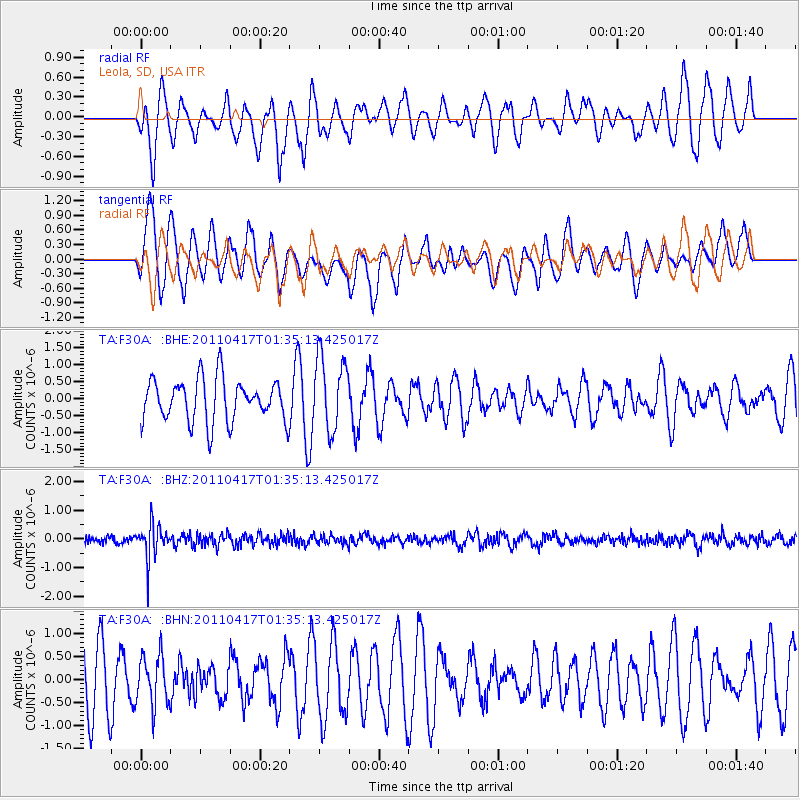
F30A Leola, SD, USA - Earthquake Result Viewer
*The percent match for this event was below the threshold and hence no stack was calculated.
| Earthquake location: |
Santiago Del Estero Prov., Arg. |
| Earthquake latitude/longitude: |
-27.6/-63.2 |
| Earthquake time(UTC): |
2011/04/17 (107) 01:24:33 GMT |
| Earthquake Depth: |
563 km |
| Earthquake Magnitude: |
5.6 MD, 5.1 MB |
| Earthquake Catalog/Contributor: |
WHDF/NEIC |
|
| Network: |
TA USArray Transportable Network (new EarthScope stations) |
| Station: |
F30A Leola, SD, USA |
| Lat/Lon: |
45.84 N/99.03 W |
| Elevation: |
601 m |
|
| Distance: |
80.0 deg |
| Az: |
335.444 deg |
| Baz: |
148.165 deg |
| Ray Param: |
$rayparam |
*The percent match for this event was below the threshold and hence was not used in the summary stack. |
|
| Radial Match: |
51.65218 % |
| Radial Bump: |
340 |
| Transverse Match: |
68.690994 % |
| Transverse Bump: |
396 |
| SOD ConfigId: |
356183 |
| Insert Time: |
2011-09-30 07:07:22.738 +0000 |
| GWidth: |
2.5 |
| Max Bumps: |
400 |
| Tol: |
0.001 |
|
Signal To Noise
| Channel | StoN | STA | LTA |
| TA:F30A: :BHZ:20110417T01:35:13.425017Z | 3.5531213 | 5.9738767E-7 | 1.6813038E-7 |
| TA:F30A: :BHN:20110417T01:35:13.425017Z | 0.8922684 | 5.3857815E-7 | 6.0360554E-7 |
| TA:F30A: :BHE:20110417T01:35:13.425017Z | 1.7229294 | 1.0795085E-6 | 6.265541E-7 |
| Arrivals |
| Ps | |
| PpPs | |
| PsPs/PpSs | |


