You are here: Home > Network List > TA - USArray Transportable Network (new EarthScope stations) Stations List
> Station A36M Sachs Harbour, NT, CAN > Earthquake Result Viewer
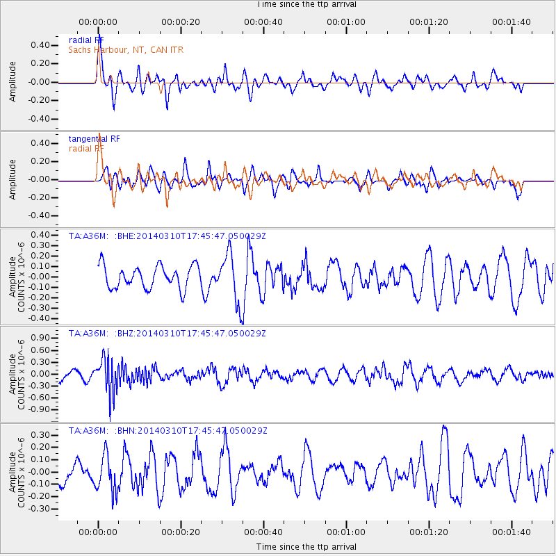
A36M Sachs Harbour, NT, CAN - Earthquake Result Viewer
*The percent match for this event was below the threshold and hence no stack was calculated.
| Earthquake location: |
Eastern New Guinea Reg., P.N.G. |
| Earthquake latitude/longitude: |
-5.5/148.0 |
| Earthquake time(UTC): |
2014/03/10 (069) 17:33:30 GMT |
| Earthquake Depth: |
269 km |
| Earthquake Magnitude: |
5.9 MWB, 5.9 MWW, 6.0 MWC |
| Earthquake Catalog/Contributor: |
NEIC PDE/NEIC COMCAT |
|
| Network: |
TA USArray Transportable Network (new EarthScope stations) |
| Station: |
A36M Sachs Harbour, NT, CAN |
| Lat/Lon: |
71.99 N/125.25 W |
| Elevation: |
32 m |
|
| Distance: |
94.2 deg |
| Az: |
18.147 deg |
| Baz: |
265.251 deg |
| Ray Param: |
$rayparam |
*The percent match for this event was below the threshold and hence was not used in the summary stack. |
|
| Radial Match: |
73.65616 % |
| Radial Bump: |
400 |
| Transverse Match: |
56.649323 % |
| Transverse Bump: |
400 |
| SOD ConfigId: |
3390531 |
| Insert Time: |
2019-04-10 14:20:02.335 +0000 |
| GWidth: |
2.5 |
| Max Bumps: |
400 |
| Tol: |
0.001 |
|
Signal To Noise
| Channel | StoN | STA | LTA |
| TA:A36M: :BHZ:20140310T17:45:47.050029Z | 4.7235246 | 4.408294E-7 | 9.332638E-8 |
| TA:A36M: :BHN:20140310T17:45:47.050029Z | 1.546046 | 1.5173156E-7 | 9.8141676E-8 |
| TA:A36M: :BHE:20140310T17:45:47.050029Z | 2.2120817 | 2.3788056E-7 | 1.0753697E-7 |
| Arrivals |
| Ps | |
| PpPs | |
| PsPs/PpSs | |


