You are here: Home > Network List > TA - USArray Transportable Network (new EarthScope stations) Stations List
> Station Z34A Collier Ranch, Chico, TX, USA > Earthquake Result Viewer
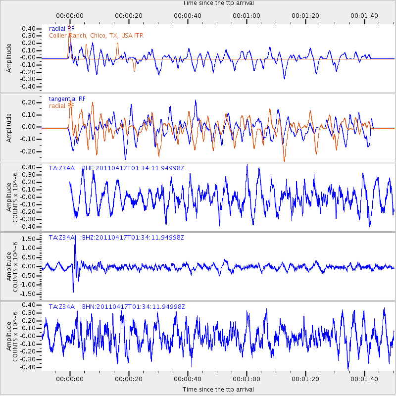
Z34A Collier Ranch, Chico, TX, USA - Earthquake Result Viewer
*The percent match for this event was below the threshold and hence no stack was calculated.
| Earthquake location: |
Santiago Del Estero Prov., Arg. |
| Earthquake latitude/longitude: |
-27.6/-63.2 |
| Earthquake time(UTC): |
2011/04/17 (107) 01:24:33 GMT |
| Earthquake Depth: |
563 km |
| Earthquake Magnitude: |
5.6 MD, 5.1 MB |
| Earthquake Catalog/Contributor: |
WHDF/NEIC |
|
| Network: |
TA USArray Transportable Network (new EarthScope stations) |
| Station: |
Z34A Collier Ranch, Chico, TX, USA |
| Lat/Lon: |
33.37 N/97.92 W |
| Elevation: |
341 m |
|
| Distance: |
69.0 deg |
| Az: |
329.303 deg |
| Baz: |
147.227 deg |
| Ray Param: |
$rayparam |
*The percent match for this event was below the threshold and hence was not used in the summary stack. |
|
| Radial Match: |
42.017517 % |
| Radial Bump: |
400 |
| Transverse Match: |
56.932304 % |
| Transverse Bump: |
400 |
| SOD ConfigId: |
356183 |
| Insert Time: |
2011-09-30 07:20:20.991 +0000 |
| GWidth: |
2.5 |
| Max Bumps: |
400 |
| Tol: |
0.001 |
|
Signal To Noise
| Channel | StoN | STA | LTA |
| TA:Z34A: :BHZ:20110417T01:34:11.94998Z | 4.5442467 | 5.143246E-7 | 1.1318148E-7 |
| TA:Z34A: :BHN:20110417T01:34:11.94998Z | 1.1665809 | 1.285109E-7 | 1.101603E-7 |
| TA:Z34A: :BHE:20110417T01:34:11.94998Z | 0.97879946 | 1.4872722E-7 | 1.5194861E-7 |
| Arrivals |
| Ps | |
| PpPs | |
| PsPs/PpSs | |


