You are here: Home > Network List > AZ - ANZA Regional Network Stations List
> Station SMTC AZ.SMTC > Earthquake Result Viewer
SMTC AZ.SMTC - Earthquake Result Viewer

| Earthquake location: |
Kermadec Islands Region |
| Earthquake latitude/longitude: |
-31.9/-179.0 |
| Earthquake time(UTC): |
1999/04/20 (110) 19:04:08 GMT |
| Earthquake Depth: |
96 km |
| Earthquake Magnitude: |
6.2 MB, 6.5 MW, 6.5 MW |
| Earthquake Catalog/Contributor: |
WHDF/NEIC |
|
| Network: |
AZ ANZA Regional Network |
| Station: |
SMTC AZ.SMTC |
| Lat/Lon: |
32.94 N/115.80 W |
| Elevation: |
100 m |
|
| Distance: |
87.8 deg |
| Az: |
48.706 deg |
| Baz: |
229.473 deg |
| Ray Param: |
0.042825006 |
| Estimated Moho Depth: |
31.25 km |
| Estimated Crust Vp/Vs: |
1.62 |
| Assumed Crust Vp: |
6.155 km/s |
| Estimated Crust Vs: |
3.811 km/s |
| Estimated Crust Poisson's Ratio: |
0.19 |
|
| Radial Match: |
87.23964 % |
| Radial Bump: |
400 |
| Transverse Match: |
75.59926 % |
| Transverse Bump: |
400 |
| SOD ConfigId: |
32974 |
| Insert Time: |
2010-02-26 20:49:46.527 +0000 |
| GWidth: |
2.5 |
| Max Bumps: |
400 |
| Tol: |
0.001 |
|
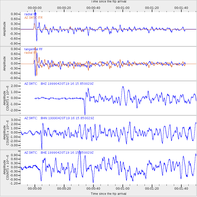
Signal To Noise
| Channel | StoN | STA | LTA |
| AZ:SMTC: :BHN:19990420T19:16:15.850029Z | 3.170329 | 9.1183074E-7 | 2.8761391E-7 |
| AZ:SMTC: :BHE:19990420T19:16:15.850029Z | 3.4182496 | 3.49205E-7 | 1.02159014E-7 |
| AZ:SMTC: :BHZ:19990420T19:16:15.850029Z | 11.52478 | 8.2012724E-7 | 7.116208E-8 |
| Arrivals |
| Ps | 3.2 SECOND |
| PpPs | 13 SECOND |
| PsPs/PpSs | 16 SECOND |


