You are here: Home > Network List > AZ - ANZA Regional Network Stations List
> Station SMTC AZ.SMTC > Earthquake Result Viewer
SMTC AZ.SMTC - Earthquake Result Viewer
| Earthquake location: |
Fiji Islands Region |
| Earthquake latitude/longitude: |
-21.4/-176.5 |
| Earthquake time(UTC): |
1999/04/13 (103) 10:38:48 GMT |
| Earthquake Depth: |
164 km |
| Earthquake Magnitude: |
6.4 MB, 6.8 MW, 6.8 MW |
| Earthquake Catalog/Contributor: |
WHDF/NEIC |
|
| Network: |
AZ ANZA Regional Network |
| Station: |
SMTC AZ.SMTC |
| Lat/Lon: |
32.94 N/115.80 W |
| Elevation: |
100 m |
|
| Distance: |
79.2 deg |
| Az: |
48.263 deg |
| Baz: |
235.779 deg |
| Ray Param: |
0.04872082 |
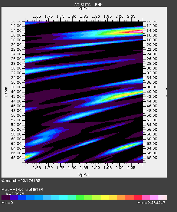
| Estimated Moho Depth: |
14.0 km |
| Estimated Crust Vp/Vs: |
2.10 |
| Assumed Crust Vp: |
6.155 km/s |
| Estimated Crust Vs: |
2.934 km/s |
| Estimated Crust Poisson's Ratio: |
0.35 |
|
| Radial Match: |
90.176155 % |
| Radial Bump: |
399 |
| Transverse Match: |
82.78066 % |
| Transverse Bump: |
400 |
| SOD ConfigId: |
32974 |
| Insert Time: |
2010-02-26 20:49:47.976 +0000 |
| GWidth: |
2.5 |
| Max Bumps: |
400 |
| Tol: |
0.001 |
|

Signal To Noise
| Channel | StoN | STA | LTA |
| AZ:SMTC: :BHN:19990413T10:50:04.074011Z | 1.1482651 | 4.9408806E-7 | 4.3029095E-7 |
| AZ:SMTC: :BHE:19990413T10:50:04.074011Z | 0.62426895 | 1.9206858E-7 | 3.076696E-7 |
| AZ:SMTC: :BHZ:19990413T10:50:04.074011Z | 2.1598516 | 4.3897313E-7 | 2.0324228E-7 |
| Arrivals |
| Ps | 2.6 SECOND |
| PpPs | 6.9 SECOND |
| PsPs/PpSs | 9.4 SECOND |


