You are here: Home > Network List > TA - USArray Transportable Network (new EarthScope stations) Stations List
> Station W36A Wetumka, OK, USA > Earthquake Result Viewer
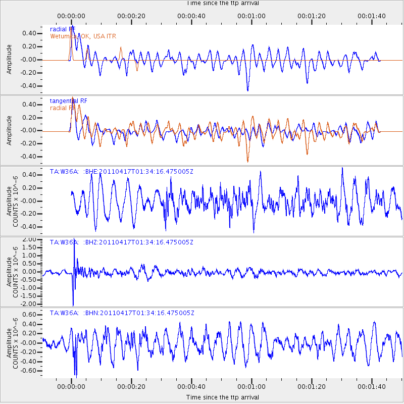
W36A Wetumka, OK, USA - Earthquake Result Viewer
*The percent match for this event was below the threshold and hence no stack was calculated.
| Earthquake location: |
Santiago Del Estero Prov., Arg. |
| Earthquake latitude/longitude: |
-27.6/-63.2 |
| Earthquake time(UTC): |
2011/04/17 (107) 01:24:33 GMT |
| Earthquake Depth: |
563 km |
| Earthquake Magnitude: |
5.6 MD, 5.1 MB |
| Earthquake Catalog/Contributor: |
WHDF/NEIC |
|
| Network: |
TA USArray Transportable Network (new EarthScope stations) |
| Station: |
W36A Wetumka, OK, USA |
| Lat/Lon: |
35.14 N/96.23 W |
| Elevation: |
251 m |
|
| Distance: |
69.8 deg |
| Az: |
331.568 deg |
| Baz: |
148.97 deg |
| Ray Param: |
$rayparam |
*The percent match for this event was below the threshold and hence was not used in the summary stack. |
|
| Radial Match: |
60.800903 % |
| Radial Bump: |
400 |
| Transverse Match: |
79.493256 % |
| Transverse Bump: |
400 |
| SOD ConfigId: |
356183 |
| Insert Time: |
2011-09-30 07:36:03.528 +0000 |
| GWidth: |
2.5 |
| Max Bumps: |
400 |
| Tol: |
0.001 |
|
Signal To Noise
| Channel | StoN | STA | LTA |
| TA:W36A: :BHZ:20110417T01:34:16.475005Z | 4.2628226 | 5.901209E-7 | 1.384343E-7 |
| TA:W36A: :BHN:20110417T01:34:16.475005Z | 1.7365932 | 2.4700142E-7 | 1.4223332E-7 |
| TA:W36A: :BHE:20110417T01:34:16.475005Z | 0.7897817 | 1.6832772E-7 | 2.1313195E-7 |
| Arrivals |
| Ps | |
| PpPs | |
| PsPs/PpSs | |


