You are here: Home > Network List > AZ - ANZA Regional Network Stations List
> Station SMTC AZ.SMTC > Earthquake Result Viewer
SMTC AZ.SMTC - Earthquake Result Viewer
| Earthquake location: |
South Of Fiji Islands |
| Earthquake latitude/longitude: |
-26.4/178.2 |
| Earthquake time(UTC): |
1999/04/09 (099) 12:16:01 GMT |
| Earthquake Depth: |
621 km |
| Earthquake Magnitude: |
5.5 MB, 6.2 MW, 6.1 MW |
| Earthquake Catalog/Contributor: |
WHDF/NEIC |
|
| Network: |
AZ ANZA Regional Network |
| Station: |
SMTC AZ.SMTC |
| Lat/Lon: |
32.94 N/115.80 W |
| Elevation: |
100 m |
|
| Distance: |
86.1 deg |
| Az: |
50.338 deg |
| Baz: |
235.231 deg |
| Ray Param: |
0.042472515 |
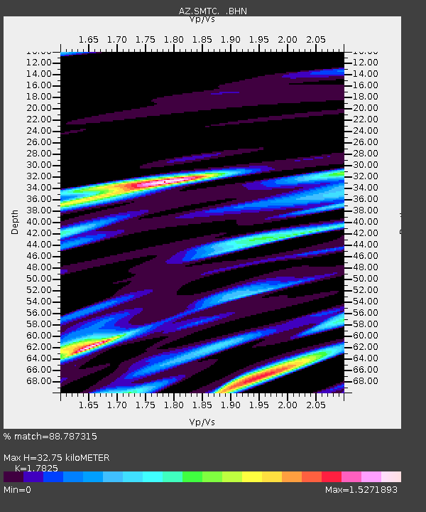
| Estimated Moho Depth: |
32.75 km |
| Estimated Crust Vp/Vs: |
1.78 |
| Assumed Crust Vp: |
6.155 km/s |
| Estimated Crust Vs: |
3.453 km/s |
| Estimated Crust Poisson's Ratio: |
0.27 |
|
| Radial Match: |
88.787315 % |
| Radial Bump: |
368 |
| Transverse Match: |
76.43772 % |
| Transverse Bump: |
400 |
| SOD ConfigId: |
32974 |
| Insert Time: |
2010-02-26 20:49:51.665 +0000 |
| GWidth: |
2.5 |
| Max Bumps: |
400 |
| Tol: |
0.001 |
|

Signal To Noise
| Channel | StoN | STA | LTA |
| AZ:SMTC: :BHN:19990409T12:27:07.199021Z | 1.52444 | 1.2681611E-6 | 8.318865E-7 |
| AZ:SMTC: :BHE:19990409T12:27:07.199021Z | 1.726457 | 6.737244E-7 | 3.9023527E-7 |
| AZ:SMTC: :BHZ:19990409T12:27:07.199021Z | 2.8951986 | 6.453948E-7 | 2.22919E-7 |
| Arrivals |
| Ps | 4.2 SECOND |
| PpPs | 15 SECOND |
| PsPs/PpSs | 19 SECOND |


