You are here: Home > Network List > TA - USArray Transportable Network (new EarthScope stations) Stations List
> Station G36A St. Michael, MN, USA > Earthquake Result Viewer
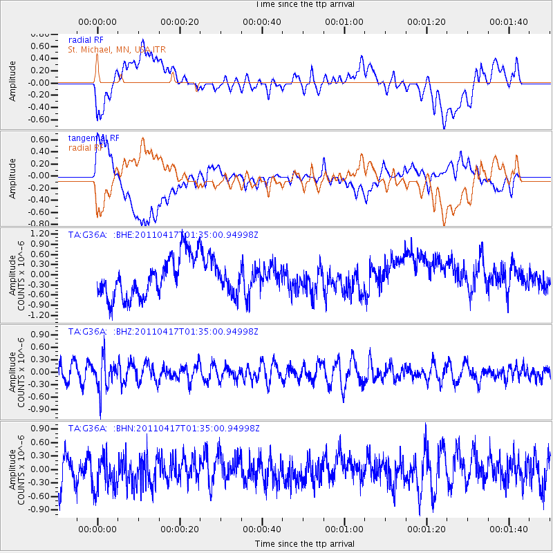
G36A St. Michael, MN, USA - Earthquake Result Viewer
*The percent match for this event was below the threshold and hence no stack was calculated.
| Earthquake location: |
Santiago Del Estero Prov., Arg. |
| Earthquake latitude/longitude: |
-27.6/-63.2 |
| Earthquake time(UTC): |
2011/04/17 (107) 01:24:33 GMT |
| Earthquake Depth: |
563 km |
| Earthquake Magnitude: |
5.6 MD, 5.1 MB |
| Earthquake Catalog/Contributor: |
WHDF/NEIC |
|
| Network: |
TA USArray Transportable Network (new EarthScope stations) |
| Station: |
G36A St. Michael, MN, USA |
| Lat/Lon: |
45.23 N/93.75 W |
| Elevation: |
293 m |
|
| Distance: |
77.7 deg |
| Az: |
338.423 deg |
| Baz: |
152.495 deg |
| Ray Param: |
$rayparam |
*The percent match for this event was below the threshold and hence was not used in the summary stack. |
|
| Radial Match: |
43.544643 % |
| Radial Bump: |
400 |
| Transverse Match: |
33.203728 % |
| Transverse Bump: |
400 |
| SOD ConfigId: |
356183 |
| Insert Time: |
2011-09-30 08:12:20.267 +0000 |
| GWidth: |
2.5 |
| Max Bumps: |
400 |
| Tol: |
0.001 |
|
Signal To Noise
| Channel | StoN | STA | LTA |
| TA:G36A: :BHZ:20110417T01:35:00.94998Z | 1.900083 | 3.7132554E-7 | 1.9542597E-7 |
| TA:G36A: :BHN:20110417T01:35:00.94998Z | 1.3102286 | 4.1466177E-7 | 3.1648048E-7 |
| TA:G36A: :BHE:20110417T01:35:00.94998Z | 0.5969846 | 3.593902E-7 | 6.020092E-7 |
| Arrivals |
| Ps | |
| PpPs | |
| PsPs/PpSs | |


