You are here: Home > Network List > TA - USArray Transportable Network (new EarthScope stations) Stations List
> Station T40A Mansfield, MO, USA > Earthquake Result Viewer
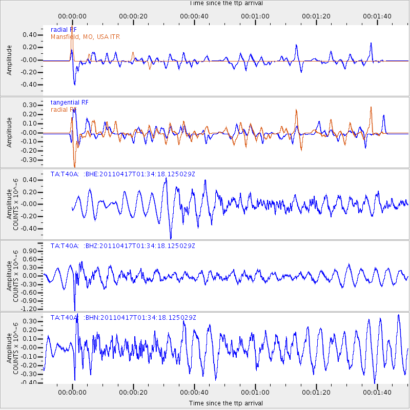
T40A Mansfield, MO, USA - Earthquake Result Viewer
*The percent match for this event was below the threshold and hence no stack was calculated.
| Earthquake location: |
Santiago Del Estero Prov., Arg. |
| Earthquake latitude/longitude: |
-27.6/-63.2 |
| Earthquake time(UTC): |
2011/04/17 (107) 01:24:33 GMT |
| Earthquake Depth: |
563 km |
| Earthquake Magnitude: |
5.6 MD, 5.1 MB |
| Earthquake Catalog/Contributor: |
WHDF/NEIC |
|
| Network: |
TA USArray Transportable Network (new EarthScope stations) |
| Station: |
T40A Mansfield, MO, USA |
| Lat/Lon: |
37.15 N/92.52 W |
| Elevation: |
399 m |
|
| Distance: |
70.1 deg |
| Az: |
335.399 deg |
| Baz: |
152.463 deg |
| Ray Param: |
$rayparam |
*The percent match for this event was below the threshold and hence was not used in the summary stack. |
|
| Radial Match: |
65.87758 % |
| Radial Bump: |
400 |
| Transverse Match: |
67.83379 % |
| Transverse Bump: |
400 |
| SOD ConfigId: |
356183 |
| Insert Time: |
2011-09-30 08:26:05.834 +0000 |
| GWidth: |
2.5 |
| Max Bumps: |
400 |
| Tol: |
0.001 |
|
Signal To Noise
| Channel | StoN | STA | LTA |
| TA:T40A: :BHZ:20110417T01:34:18.125029Z | 2.8197672 | 3.8797054E-7 | 1.3758957E-7 |
| TA:T40A: :BHN:20110417T01:34:18.125029Z | 1.5490731 | 1.5746386E-7 | 1.0165037E-7 |
| TA:T40A: :BHE:20110417T01:34:18.125029Z | 2.3039246 | 2.8816987E-7 | 1.2507782E-7 |
| Arrivals |
| Ps | |
| PpPs | |
| PsPs/PpSs | |


