You are here: Home > Network List > TA - USArray Transportable Network (new EarthScope stations) Stations List
> Station Z40A Long Farm, Magnolia, AR, USA > Earthquake Result Viewer
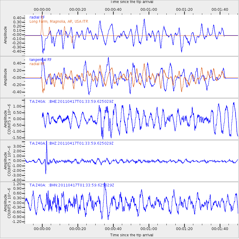
Z40A Long Farm, Magnolia, AR, USA - Earthquake Result Viewer
*The percent match for this event was below the threshold and hence no stack was calculated.
| Earthquake location: |
Santiago Del Estero Prov., Arg. |
| Earthquake latitude/longitude: |
-27.6/-63.2 |
| Earthquake time(UTC): |
2011/04/17 (107) 01:24:33 GMT |
| Earthquake Depth: |
563 km |
| Earthquake Magnitude: |
5.6 MD, 5.1 MB |
| Earthquake Catalog/Contributor: |
WHDF/NEIC |
|
| Network: |
TA USArray Transportable Network (new EarthScope stations) |
| Station: |
Z40A Long Farm, Magnolia, AR, USA |
| Lat/Lon: |
33.26 N/93.40 W |
| Elevation: |
78 m |
|
| Distance: |
67.0 deg |
| Az: |
332.74 deg |
| Baz: |
150.984 deg |
| Ray Param: |
$rayparam |
*The percent match for this event was below the threshold and hence was not used in the summary stack. |
|
| Radial Match: |
37.193268 % |
| Radial Bump: |
400 |
| Transverse Match: |
69.54061 % |
| Transverse Bump: |
400 |
| SOD ConfigId: |
356183 |
| Insert Time: |
2011-09-30 08:30:36.554 +0000 |
| GWidth: |
2.5 |
| Max Bumps: |
400 |
| Tol: |
0.001 |
|
Signal To Noise
| Channel | StoN | STA | LTA |
| TA:Z40A: :BHZ:20110417T01:33:59.625029Z | 5.765377 | 1.0688401E-6 | 1.8538945E-7 |
| TA:Z40A: :BHN:20110417T01:33:59.625029Z | 0.5691697 | 3.269149E-7 | 5.7437154E-7 |
| TA:Z40A: :BHE:20110417T01:33:59.625029Z | 2.2097204 | 6.944044E-7 | 3.142499E-7 |
| Arrivals |
| Ps | |
| PpPs | |
| PsPs/PpSs | |


