You are here: Home > Network List > TA - USArray Transportable Network (new EarthScope stations) Stations List
> Station Y43A Makayla and Karen, Gunnison, MS, USA > Earthquake Result Viewer
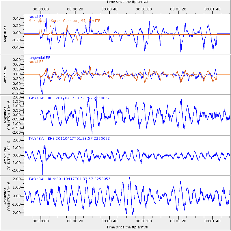
Y43A Makayla and Karen, Gunnison, MS, USA - Earthquake Result Viewer
*The percent match for this event was below the threshold and hence no stack was calculated.
| Earthquake location: |
Santiago Del Estero Prov., Arg. |
| Earthquake latitude/longitude: |
-27.6/-63.2 |
| Earthquake time(UTC): |
2011/04/17 (107) 01:24:33 GMT |
| Earthquake Depth: |
563 km |
| Earthquake Magnitude: |
5.6 MD, 5.1 MB |
| Earthquake Catalog/Contributor: |
WHDF/NEIC |
|
| Network: |
TA USArray Transportable Network (new EarthScope stations) |
| Station: |
Y43A Makayla and Karen, Gunnison, MS, USA |
| Lat/Lon: |
33.91 N/90.93 W |
| Elevation: |
46 m |
|
| Distance: |
66.6 deg |
| Az: |
335.056 deg |
| Baz: |
153.257 deg |
| Ray Param: |
$rayparam |
*The percent match for this event was below the threshold and hence was not used in the summary stack. |
|
| Radial Match: |
46.69776 % |
| Radial Bump: |
400 |
| Transverse Match: |
59.127686 % |
| Transverse Bump: |
400 |
| SOD ConfigId: |
356183 |
| Insert Time: |
2011-09-30 08:36:39.011 +0000 |
| GWidth: |
2.5 |
| Max Bumps: |
400 |
| Tol: |
0.001 |
|
Signal To Noise
| Channel | StoN | STA | LTA |
| TA:Y43A: :BHZ:20110417T01:33:57.225005Z | 2.194574 | 8.0378885E-7 | 3.662619E-7 |
| TA:Y43A: :BHN:20110417T01:33:57.225005Z | 0.76765776 | 5.6520366E-7 | 7.3627035E-7 |
| TA:Y43A: :BHE:20110417T01:33:57.225005Z | 1.87601 | 1.2273722E-6 | 6.542461E-7 |
| Arrivals |
| Ps | |
| PpPs | |
| PsPs/PpSs | |


