You are here: Home > Network List > CI - Caltech Regional Seismic Network Stations List
> Station MPP McPhearson Peak > Earthquake Result Viewer
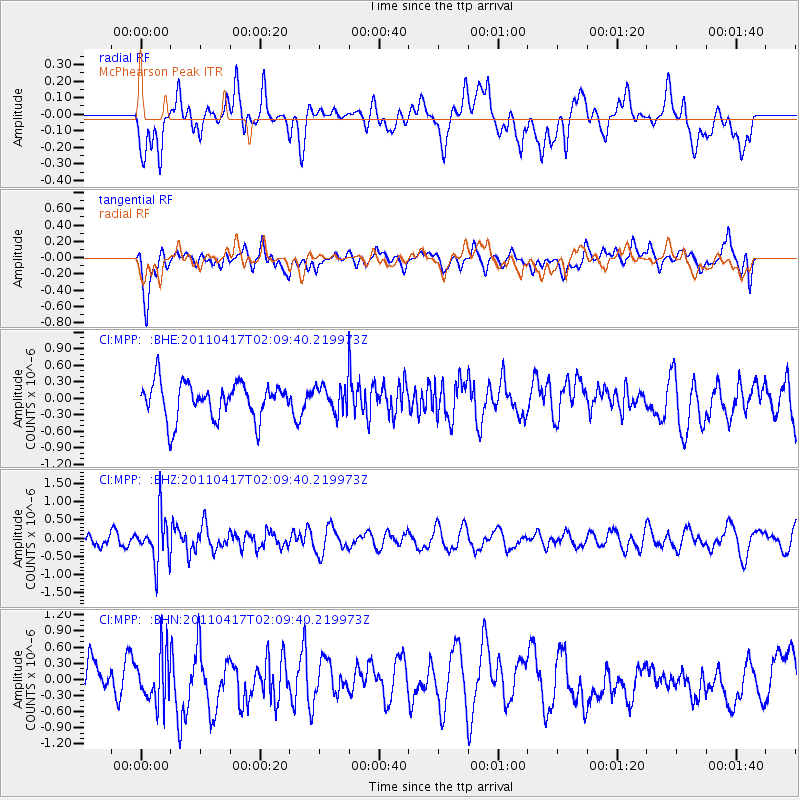
MPP McPhearson Peak - Earthquake Result Viewer
*The percent match for this event was below the threshold and hence no stack was calculated.
| Earthquake location: |
Santiago Del Estero Prov., Arg. |
| Earthquake latitude/longitude: |
-27.6/-63.2 |
| Earthquake time(UTC): |
2011/04/17 (107) 01:58:49 GMT |
| Earthquake Depth: |
557 km |
| Earthquake Magnitude: |
5.6 MB, 5.9 MW, 5.8 MW |
| Earthquake Catalog/Contributor: |
WHDF/NEIC |
|
| Network: |
CI Caltech Regional Seismic Network |
| Station: |
MPP McPhearson Peak |
| Lat/Lon: |
34.89 N/119.81 W |
| Elevation: |
1739 m |
|
| Distance: |
82.0 deg |
| Az: |
316.121 deg |
| Baz: |
131.555 deg |
| Ray Param: |
$rayparam |
*The percent match for this event was below the threshold and hence was not used in the summary stack. |
|
| Radial Match: |
35.940144 % |
| Radial Bump: |
400 |
| Transverse Match: |
62.249985 % |
| Transverse Bump: |
400 |
| SOD ConfigId: |
356183 |
| Insert Time: |
2011-09-30 09:11:17.041 +0000 |
| GWidth: |
2.5 |
| Max Bumps: |
400 |
| Tol: |
0.001 |
|
Signal To Noise
| Channel | StoN | STA | LTA |
| CI:MPP: :BHZ:20110417T02:09:40.219973Z | 2.6211908 | 6.3325757E-7 | 2.4159155E-7 |
| CI:MPP: :BHN:20110417T02:09:40.219973Z | 1.5991583 | 4.5627345E-7 | 2.8532102E-7 |
| CI:MPP: :BHE:20110417T02:09:40.219973Z | 0.7449407 | 2.4338286E-7 | 3.267144E-7 |
| Arrivals |
| Ps | |
| PpPs | |
| PsPs/PpSs | |


