You are here: Home > Network List > UW - Pacific Northwest Regional Seismic Network Stations List
> Station HOOD Mt Hood Meadows, OR CREST BB SMO > Earthquake Result Viewer
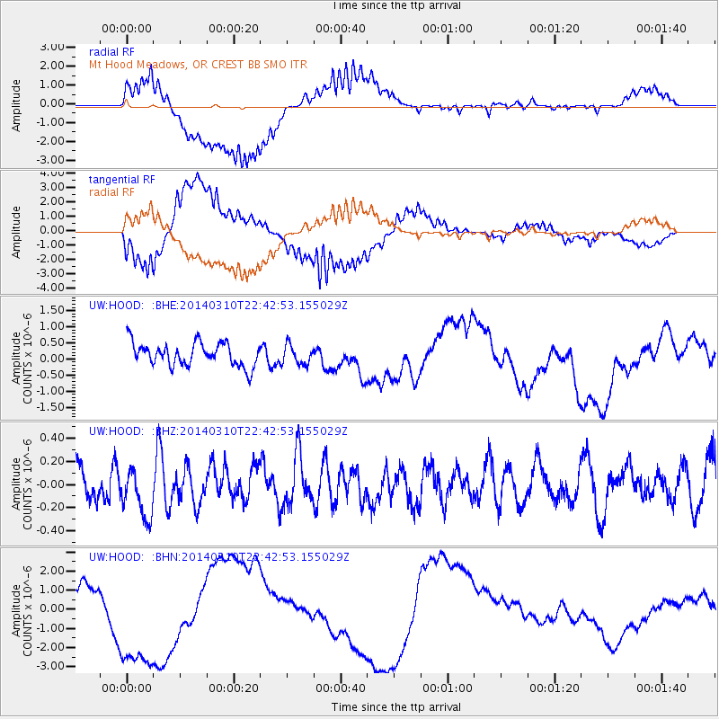
HOOD Mt Hood Meadows, OR CREST BB SMO - Earthquake Result Viewer
*The percent match for this event was below the threshold and hence no stack was calculated.
| Earthquake location: |
Kermadec Islands Region |
| Earthquake latitude/longitude: |
-27.5/-178.0 |
| Earthquake time(UTC): |
2014/03/10 (069) 22:30:47 GMT |
| Earthquake Depth: |
150 km |
| Earthquake Magnitude: |
4.7 mb |
| Earthquake Catalog/Contributor: |
ISC/ISC |
|
| Network: |
UW Pacific Northwest Regional Seismic Network |
| Station: |
HOOD Mt Hood Meadows, OR CREST BB SMO |
| Lat/Lon: |
45.32 N/121.65 W |
| Elevation: |
1520 m |
|
| Distance: |
88.7 deg |
| Az: |
35.962 deg |
| Baz: |
227.676 deg |
| Ray Param: |
$rayparam |
*The percent match for this event was below the threshold and hence was not used in the summary stack. |
|
| Radial Match: |
77.39531 % |
| Radial Bump: |
400 |
| Transverse Match: |
76.64666 % |
| Transverse Bump: |
400 |
| SOD ConfigId: |
3390531 |
| Insert Time: |
2019-04-10 14:29:42.670 +0000 |
| GWidth: |
2.5 |
| Max Bumps: |
400 |
| Tol: |
0.001 |
|
Signal To Noise
| Channel | StoN | STA | LTA |
| UW:HOOD: :BHZ:20140310T22:42:53.155029Z | 1.439291 | 2.1710981E-7 | 1.5084498E-7 |
| UW:HOOD: :BHN:20140310T22:42:53.155029Z | 4.361315 | 3.0819244E-6 | 7.066503E-7 |
| UW:HOOD: :BHE:20140310T22:42:53.155029Z | 0.82672364 | 3.0107861E-7 | 3.6418288E-7 |
| Arrivals |
| Ps | |
| PpPs | |
| PsPs/PpSs | |


