You are here: Home > Network List > UW - Pacific Northwest Regional Seismic Network Stations List
> Station UMAT Pilot Rock, OR, USA > Earthquake Result Viewer
UMAT Pilot Rock, OR, USA - Earthquake Result Viewer
*The percent match for this event was below the threshold and hence no stack was calculated.
| Earthquake location: |
Kermadec Islands Region |
| Earthquake latitude/longitude: |
-27.5/-178.0 |
| Earthquake time(UTC): |
2014/03/10 (069) 22:30:47 GMT |
| Earthquake Depth: |
150 km |
| Earthquake Magnitude: |
4.7 mb |
| Earthquake Catalog/Contributor: |
ISC/ISC |
|
| Network: |
UW Pacific Northwest Regional Seismic Network |
| Station: |
UMAT Pilot Rock, OR, USA |
| Lat/Lon: |
45.29 N/118.96 W |
| Elevation: |
1318 m |
|
| Distance: |
90.1 deg |
| Az: |
37.241 deg |
| Baz: |
229.597 deg |
| Ray Param: |
$rayparam |
*The percent match for this event was below the threshold and hence was not used in the summary stack. |
|
| Radial Match: |
44.7017 % |
| Radial Bump: |
400 |
| Transverse Match: |
44.133312 % |
| Transverse Bump: |
400 |
| SOD ConfigId: |
3390531 |
| Insert Time: |
2019-04-10 14:29:46.805 +0000 |
| GWidth: |
2.5 |
| Max Bumps: |
400 |
| Tol: |
0.001 |
|
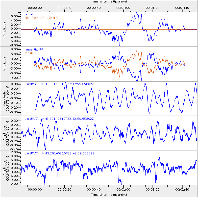
Signal To Noise
| Channel | StoN | STA | LTA |
| UW:UMAT: :HHZ:20140310T22:42:59.65802Z | 1.5327035 | 1.9118133E-7 | 1.2473471E-7 |
| UW:UMAT: :HHN:20140310T22:42:59.65802Z | 0.9360277 | 4.452797E-6 | 4.7571207E-6 |
| UW:UMAT: :HHE:20140310T22:42:59.65802Z | 0.79258615 | 1.0247571E-7 | 1.2929284E-7 |
| Arrivals |
| Ps | |
| PpPs | |
| PsPs/PpSs | |


