You are here: Home > Network List > TA - USArray Transportable Network (new EarthScope stations) Stations List
> Station 535A Dale, TX, USA > Earthquake Result Viewer
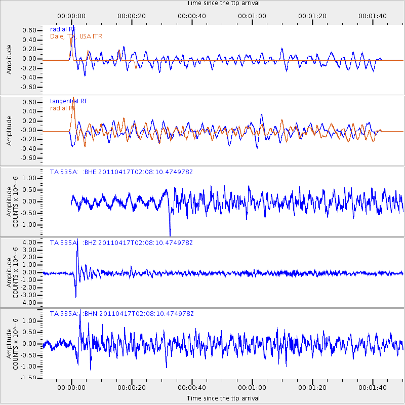
535A Dale, TX, USA - Earthquake Result Viewer
*The percent match for this event was below the threshold and hence no stack was calculated.
| Earthquake location: |
Santiago Del Estero Prov., Arg. |
| Earthquake latitude/longitude: |
-27.6/-63.2 |
| Earthquake time(UTC): |
2011/04/17 (107) 01:58:49 GMT |
| Earthquake Depth: |
557 km |
| Earthquake Magnitude: |
5.6 MB, 5.9 MW, 5.8 MW |
| Earthquake Catalog/Contributor: |
WHDF/NEIC |
|
| Network: |
TA USArray Transportable Network (new EarthScope stations) |
| Station: |
535A Dale, TX, USA |
| Lat/Lon: |
30.03 N/97.57 W |
| Elevation: |
170 m |
|
| Distance: |
66.1 deg |
| Az: |
327.61 deg |
| Baz: |
146.756 deg |
| Ray Param: |
$rayparam |
*The percent match for this event was below the threshold and hence was not used in the summary stack. |
|
| Radial Match: |
75.620224 % |
| Radial Bump: |
400 |
| Transverse Match: |
71.41244 % |
| Transverse Bump: |
400 |
| SOD ConfigId: |
356183 |
| Insert Time: |
2011-09-30 10:15:20.414 +0000 |
| GWidth: |
2.5 |
| Max Bumps: |
400 |
| Tol: |
0.001 |
|
Signal To Noise
| Channel | StoN | STA | LTA |
| TA:535A: :BHZ:20110417T02:08:10.474978Z | 17.46037 | 1.3005185E-6 | 7.448403E-8 |
| TA:535A: :BHN:20110417T02:08:10.474978Z | 2.8941813 | 4.2778802E-7 | 1.4780969E-7 |
| TA:535A: :BHE:20110417T02:08:10.474978Z | 2.9430602 | 4.7383713E-7 | 1.6100151E-7 |
| Arrivals |
| Ps | |
| PpPs | |
| PsPs/PpSs | |


