You are here: Home > Network List > TA - USArray Transportable Network (new EarthScope stations) Stations List
> Station 336A Riesel, TX, USA > Earthquake Result Viewer
336A Riesel, TX, USA - Earthquake Result Viewer
| Earthquake location: |
Santiago Del Estero Prov., Arg. |
| Earthquake latitude/longitude: |
-27.6/-63.2 |
| Earthquake time(UTC): |
2011/04/17 (107) 01:58:49 GMT |
| Earthquake Depth: |
557 km |
| Earthquake Magnitude: |
5.6 MB, 5.9 MW, 5.8 MW |
| Earthquake Catalog/Contributor: |
WHDF/NEIC |
|
| Network: |
TA USArray Transportable Network (new EarthScope stations) |
| Station: |
336A Riesel, TX, USA |
| Lat/Lon: |
31.39 N/96.84 W |
| Elevation: |
140 m |
|
| Distance: |
66.9 deg |
| Az: |
328.984 deg |
| Baz: |
147.674 deg |
| Ray Param: |
0.055355735 |
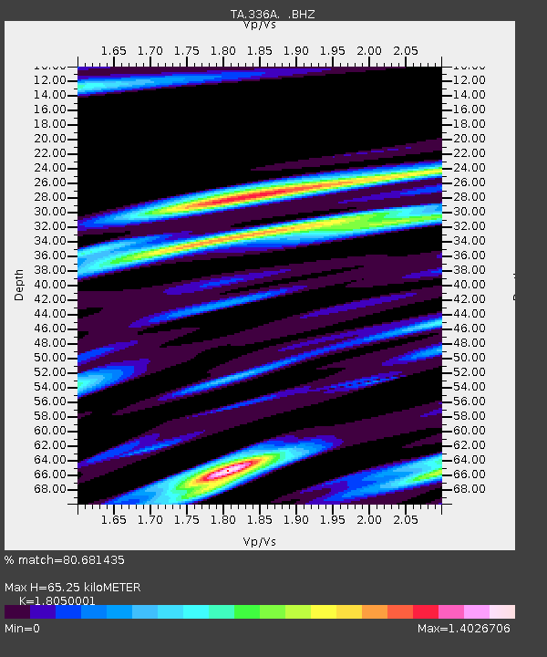
| Estimated Moho Depth: |
65.25 km |
| Estimated Crust Vp/Vs: |
1.81 |
| Assumed Crust Vp: |
6.347 km/s |
| Estimated Crust Vs: |
3.516 km/s |
| Estimated Crust Poisson's Ratio: |
0.28 |
|
| Radial Match: |
80.681435 % |
| Radial Bump: |
400 |
| Transverse Match: |
61.104366 % |
| Transverse Bump: |
400 |
| SOD ConfigId: |
356183 |
| Insert Time: |
2011-09-30 10:20:46.010 +0000 |
| GWidth: |
2.5 |
| Max Bumps: |
400 |
| Tol: |
0.001 |
|
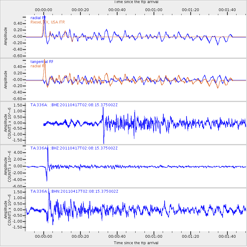
Signal To Noise
| Channel | StoN | STA | LTA |
| TA:336A: :BHZ:20110417T02:08:15.375002Z | 21.916058 | 1.7419372E-6 | 7.9482234E-8 |
| TA:336A: :BHN:20110417T02:08:15.375002Z | 4.194804 | 6.084186E-7 | 1.45041E-7 |
| TA:336A: :BHE:20110417T02:08:15.375002Z | 4.085975 | 5.310264E-7 | 1.299632E-7 |
| Arrivals |
| Ps | 8.6 SECOND |
| PpPs | 28 SECOND |
| PsPs/PpSs | 36 SECOND |


