You are here: Home > Network List > TA - USArray Transportable Network (new EarthScope stations) Stations List
> Station X38A Whitesboro, OK, USA > Earthquake Result Viewer
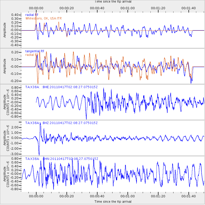
X38A Whitesboro, OK, USA - Earthquake Result Viewer
*The percent match for this event was below the threshold and hence no stack was calculated.
| Earthquake location: |
Santiago Del Estero Prov., Arg. |
| Earthquake latitude/longitude: |
-27.6/-63.2 |
| Earthquake time(UTC): |
2011/04/17 (107) 01:58:49 GMT |
| Earthquake Depth: |
557 km |
| Earthquake Magnitude: |
5.6 MB, 5.9 MW, 5.8 MW |
| Earthquake Catalog/Contributor: |
WHDF/NEIC |
|
| Network: |
TA USArray Transportable Network (new EarthScope stations) |
| Station: |
X38A Whitesboro, OK, USA |
| Lat/Lon: |
34.67 N/94.83 W |
| Elevation: |
234 m |
|
| Distance: |
68.8 deg |
| Az: |
332.376 deg |
| Baz: |
150.049 deg |
| Ray Param: |
$rayparam |
*The percent match for this event was below the threshold and hence was not used in the summary stack. |
|
| Radial Match: |
64.29327 % |
| Radial Bump: |
400 |
| Transverse Match: |
61.495495 % |
| Transverse Bump: |
400 |
| SOD ConfigId: |
356183 |
| Insert Time: |
2011-09-30 10:44:53.666 +0000 |
| GWidth: |
2.5 |
| Max Bumps: |
400 |
| Tol: |
0.001 |
|
Signal To Noise
| Channel | StoN | STA | LTA |
| TA:X38A: :BHZ:20110417T02:08:27.075015Z | 11.069645 | 1.2890133E-6 | 1.16445776E-7 |
| TA:X38A: :BHN:20110417T02:08:27.075015Z | 1.0470142 | 3.8291128E-7 | 3.6571734E-7 |
| TA:X38A: :BHE:20110417T02:08:27.075015Z | 1.7610698 | 3.479793E-7 | 1.975954E-7 |
| Arrivals |
| Ps | |
| PpPs | |
| PsPs/PpSs | |


