You are here: Home > Network List > TA - USArray Transportable Network (new EarthScope stations) Stations List
> Station V37A Hulbert, OK, USA > Earthquake Result Viewer
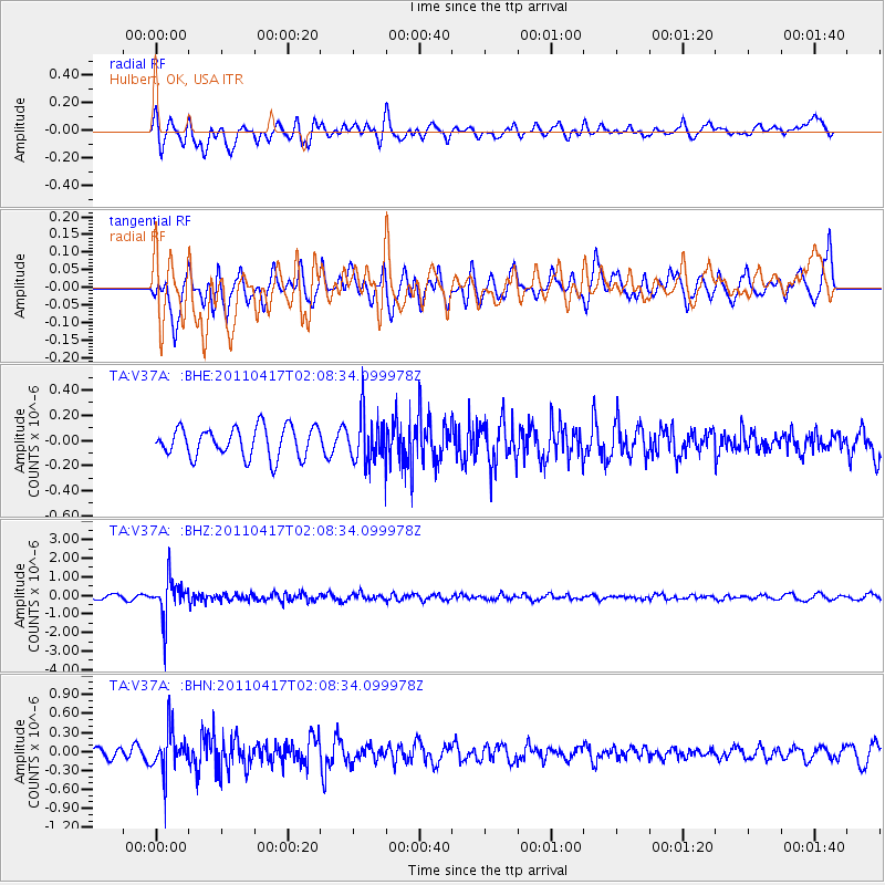
V37A Hulbert, OK, USA - Earthquake Result Viewer
*The percent match for this event was below the threshold and hence no stack was calculated.
| Earthquake location: |
Santiago Del Estero Prov., Arg. |
| Earthquake latitude/longitude: |
-27.6/-63.2 |
| Earthquake time(UTC): |
2011/04/17 (107) 01:58:49 GMT |
| Earthquake Depth: |
557 km |
| Earthquake Magnitude: |
5.6 MB, 5.9 MW, 5.8 MW |
| Earthquake Catalog/Contributor: |
WHDF/NEIC |
|
| Network: |
TA USArray Transportable Network (new EarthScope stations) |
| Station: |
V37A Hulbert, OK, USA |
| Lat/Lon: |
35.88 N/95.14 W |
| Elevation: |
219 m |
|
| Distance: |
70.0 deg |
| Az: |
332.786 deg |
| Baz: |
150.014 deg |
| Ray Param: |
$rayparam |
*The percent match for this event was below the threshold and hence was not used in the summary stack. |
|
| Radial Match: |
57.838352 % |
| Radial Bump: |
400 |
| Transverse Match: |
63.354927 % |
| Transverse Bump: |
363 |
| SOD ConfigId: |
356183 |
| Insert Time: |
2011-09-30 10:46:40.395 +0000 |
| GWidth: |
2.5 |
| Max Bumps: |
400 |
| Tol: |
0.001 |
|
Signal To Noise
| Channel | StoN | STA | LTA |
| TA:V37A: :BHZ:20110417T02:08:34.099978Z | 8.42324 | 1.0489472E-6 | 1.2453013E-7 |
| TA:V37A: :BHN:20110417T02:08:34.099978Z | 3.9147618 | 3.3970667E-7 | 8.677583E-8 |
| TA:V37A: :BHE:20110417T02:08:34.099978Z | 1.6133829 | 1.9195645E-7 | 1.189776E-7 |
| Arrivals |
| Ps | |
| PpPs | |
| PsPs/PpSs | |


