You are here: Home > Network List > II - Global Seismograph Network (GSN - IRIS/IDA) Stations List
> Station WRAB Tennant Creek, NT, Australia > Earthquake Result Viewer
WRAB Tennant Creek, NT, Australia - Earthquake Result Viewer
*The percent match for this event was below the threshold and hence no stack was calculated.
| Earthquake location: |
South Of Kermadec Islands |
| Earthquake latitude/longitude: |
-32.8/-178.1 |
| Earthquake time(UTC): |
2014/03/11 (070) 03:26:44 GMT |
| Earthquake Depth: |
34 km |
| Earthquake Magnitude: |
4.4 mb |
| Earthquake Catalog/Contributor: |
ISC/ISC |
|
| Network: |
II Global Seismograph Network (GSN - IRIS/IDA) |
| Station: |
WRAB Tennant Creek, NT, Australia |
| Lat/Lon: |
19.93 S/134.36 E |
| Elevation: |
366 m |
|
| Distance: |
44.2 deg |
| Az: |
274.62 deg |
| Baz: |
116.784 deg |
| Ray Param: |
$rayparam |
*The percent match for this event was below the threshold and hence was not used in the summary stack. |
|
| Radial Match: |
61.333763 % |
| Radial Bump: |
400 |
| Transverse Match: |
94.899216 % |
| Transverse Bump: |
304 |
| SOD ConfigId: |
3390531 |
| Insert Time: |
2019-04-10 14:35:22.481 +0000 |
| GWidth: |
2.5 |
| Max Bumps: |
400 |
| Tol: |
0.001 |
|
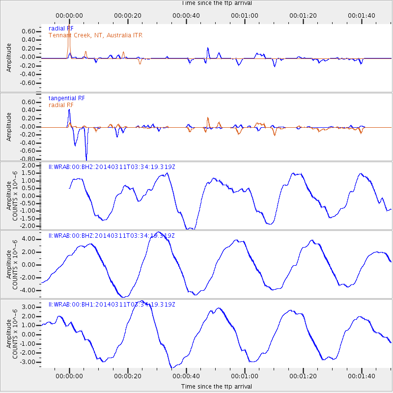
Signal To Noise
| Channel | StoN | STA | LTA |
| II:WRAB:00:BHZ:20140311T03:34:19.319Z | 1.4993516 | 2.6369703E-6 | 1.7587404E-6 |
| II:WRAB:00:BH1:20140311T03:34:19.319Z | 0.7656545 | 9.198595E-7 | 1.2014028E-6 |
| II:WRAB:00:BH2:20140311T03:34:19.319Z | 1.4840591 | 1.325228E-6 | 8.9297527E-7 |
| Arrivals |
| Ps | |
| PpPs | |
| PsPs/PpSs | |


