You are here: Home > Network List > TA - USArray Transportable Network (new EarthScope stations) Stations List
> Station J34A George, IA, USA > Earthquake Result Viewer
J34A George, IA, USA - Earthquake Result Viewer
*The percent match for this event was below the threshold and hence no stack was calculated.
| Earthquake location: |
Santiago Del Estero Prov., Arg. |
| Earthquake latitude/longitude: |
-27.6/-63.2 |
| Earthquake time(UTC): |
2011/04/17 (107) 01:58:49 GMT |
| Earthquake Depth: |
557 km |
| Earthquake Magnitude: |
5.6 MB, 5.9 MW, 5.8 MW |
| Earthquake Catalog/Contributor: |
WHDF/NEIC |
|
| Network: |
TA USArray Transportable Network (new EarthScope stations) |
| Station: |
J34A George, IA, USA |
| Lat/Lon: |
43.28 N/95.96 W |
| Elevation: |
432 m |
|
| Distance: |
76.7 deg |
| Az: |
336.044 deg |
| Baz: |
150.431 deg |
| Ray Param: |
$rayparam |
*The percent match for this event was below the threshold and hence was not used in the summary stack. |
|
| Radial Match: |
69.75983 % |
| Radial Bump: |
400 |
| Transverse Match: |
69.47322 % |
| Transverse Bump: |
400 |
| SOD ConfigId: |
356183 |
| Insert Time: |
2011-09-30 10:56:27.035 +0000 |
| GWidth: |
2.5 |
| Max Bumps: |
400 |
| Tol: |
0.001 |
|
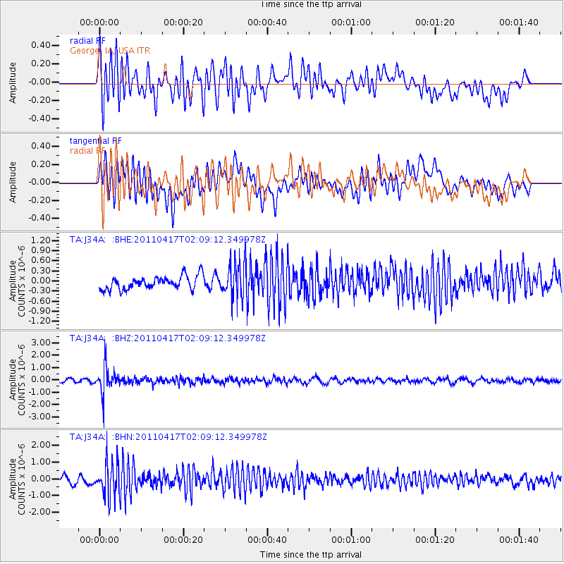
Signal To Noise
| Channel | StoN | STA | LTA |
| TA:J34A: :BHZ:20110417T02:09:12.349978Z | 8.473088 | 1.0455472E-6 | 1.2339623E-7 |
| TA:J34A: :BHN:20110417T02:09:12.349978Z | 4.6144857 | 1.0199044E-6 | 2.2102233E-7 |
| TA:J34A: :BHE:20110417T02:09:12.349978Z | 2.7853587 | 5.500125E-7 | 1.9746558E-7 |
| Arrivals |
| Ps | |
| PpPs | |
| PsPs/PpSs | |


