You are here: Home > Network List > TA - USArray Transportable Network (new EarthScope stations) Stations List
> Station F34A Alexandria, MN, USA > Earthquake Result Viewer
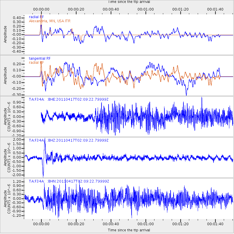
F34A Alexandria, MN, USA - Earthquake Result Viewer
*The percent match for this event was below the threshold and hence no stack was calculated.
| Earthquake location: |
Santiago Del Estero Prov., Arg. |
| Earthquake latitude/longitude: |
-27.6/-63.2 |
| Earthquake time(UTC): |
2011/04/17 (107) 01:58:49 GMT |
| Earthquake Depth: |
557 km |
| Earthquake Magnitude: |
5.6 MB, 5.9 MW, 5.8 MW |
| Earthquake Catalog/Contributor: |
WHDF/NEIC |
|
| Network: |
TA USArray Transportable Network (new EarthScope stations) |
| Station: |
F34A Alexandria, MN, USA |
| Lat/Lon: |
45.80 N/95.26 W |
| Elevation: |
419 m |
|
| Distance: |
78.6 deg |
| Az: |
337.743 deg |
| Baz: |
151.284 deg |
| Ray Param: |
$rayparam |
*The percent match for this event was below the threshold and hence was not used in the summary stack. |
|
| Radial Match: |
54.984684 % |
| Radial Bump: |
400 |
| Transverse Match: |
53.35022 % |
| Transverse Bump: |
400 |
| SOD ConfigId: |
356183 |
| Insert Time: |
2011-09-30 11:13:27.432 +0000 |
| GWidth: |
2.5 |
| Max Bumps: |
400 |
| Tol: |
0.001 |
|
Signal To Noise
| Channel | StoN | STA | LTA |
| TA:F34A: :BHZ:20110417T02:09:22.79999Z | 6.0069556 | 8.5547083E-7 | 1.4241337E-7 |
| TA:F34A: :BHN:20110417T02:09:22.79999Z | 2.334968 | 3.91685E-7 | 1.6774749E-7 |
| TA:F34A: :BHE:20110417T02:09:22.79999Z | 2.3787093 | 3.515973E-7 | 1.4781011E-7 |
| Arrivals |
| Ps | |
| PpPs | |
| PsPs/PpSs | |


