You are here: Home > Network List > TA - USArray Transportable Network (new EarthScope stations) Stations List
> Station R11A Troy Canyon, Currant, NV, USA > Earthquake Result Viewer
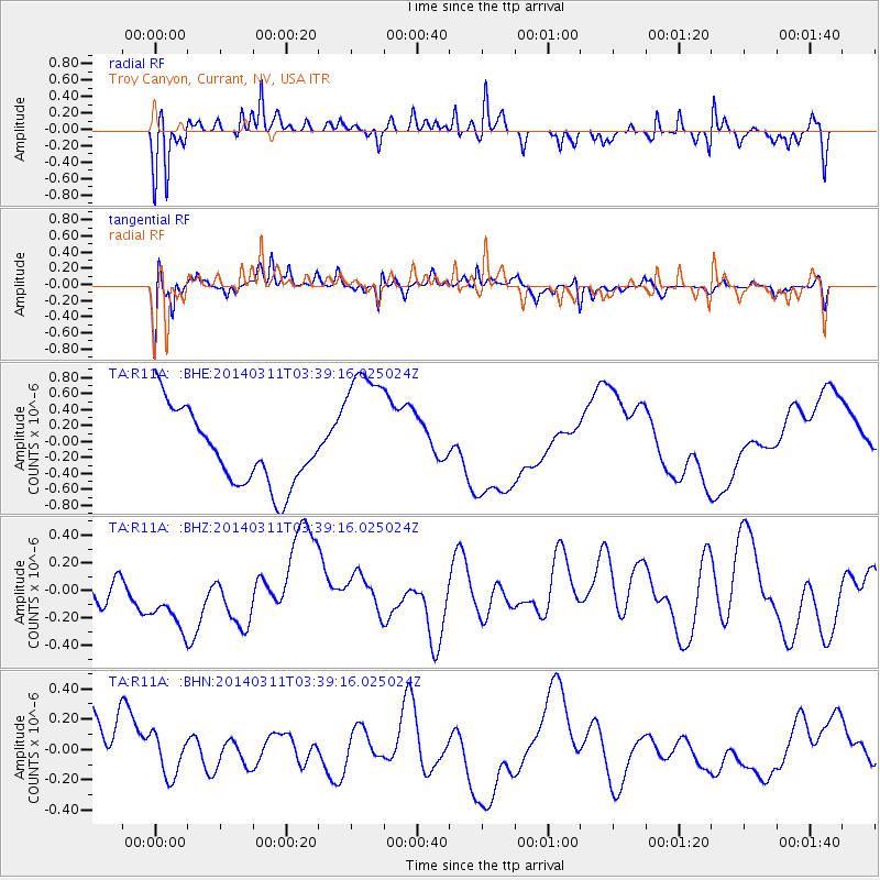
R11A Troy Canyon, Currant, NV, USA - Earthquake Result Viewer
*The percent match for this event was below the threshold and hence no stack was calculated.
| Earthquake location: |
South Of Kermadec Islands |
| Earthquake latitude/longitude: |
-32.8/-178.1 |
| Earthquake time(UTC): |
2014/03/11 (070) 03:26:44 GMT |
| Earthquake Depth: |
34 km |
| Earthquake Magnitude: |
4.4 mb |
| Earthquake Catalog/Contributor: |
ISC/ISC |
|
| Network: |
TA USArray Transportable Network (new EarthScope stations) |
| Station: |
R11A Troy Canyon, Currant, NV, USA |
| Lat/Lon: |
38.35 N/115.59 W |
| Elevation: |
1756 m |
|
| Distance: |
91.5 deg |
| Az: |
44.223 deg |
| Baz: |
228.369 deg |
| Ray Param: |
$rayparam |
*The percent match for this event was below the threshold and hence was not used in the summary stack. |
|
| Radial Match: |
75.17449 % |
| Radial Bump: |
400 |
| Transverse Match: |
58.939865 % |
| Transverse Bump: |
400 |
| SOD ConfigId: |
3390531 |
| Insert Time: |
2019-04-10 14:36:27.666 +0000 |
| GWidth: |
2.5 |
| Max Bumps: |
400 |
| Tol: |
0.001 |
|
Signal To Noise
| Channel | StoN | STA | LTA |
| TA:R11A: :BHZ:20140311T03:39:16.025024Z | 1.2351398 | 2.6408216E-7 | 2.1380748E-7 |
| TA:R11A: :BHN:20140311T03:39:16.025024Z | 0.7790779 | 1.3631278E-7 | 1.7496683E-7 |
| TA:R11A: :BHE:20140311T03:39:16.025024Z | 1.9540403 | 8.940003E-7 | 4.5751378E-7 |
| Arrivals |
| Ps | |
| PpPs | |
| PsPs/PpSs | |


