You are here: Home > Network List > US - United States National Seismic Network Stations List
> Station MSO Missoula, Montana, USA > Earthquake Result Viewer
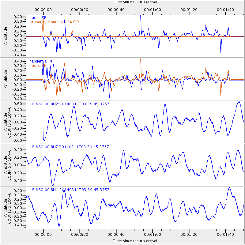
MSO Missoula, Montana, USA - Earthquake Result Viewer
*The percent match for this event was below the threshold and hence no stack was calculated.
| Earthquake location: |
South Of Kermadec Islands |
| Earthquake latitude/longitude: |
-32.8/-178.1 |
| Earthquake time(UTC): |
2014/03/11 (070) 03:26:44 GMT |
| Earthquake Depth: |
34 km |
| Earthquake Magnitude: |
4.4 mb |
| Earthquake Catalog/Contributor: |
ISC/ISC |
|
| Network: |
US United States National Seismic Network |
| Station: |
MSO Missoula, Montana, USA |
| Lat/Lon: |
46.83 N/113.94 W |
| Elevation: |
1264 m |
|
| Distance: |
98.0 deg |
| Az: |
38.591 deg |
| Baz: |
229.949 deg |
| Ray Param: |
$rayparam |
*The percent match for this event was below the threshold and hence was not used in the summary stack. |
|
| Radial Match: |
35.151447 % |
| Radial Bump: |
278 |
| Transverse Match: |
52.193413 % |
| Transverse Bump: |
330 |
| SOD ConfigId: |
3390531 |
| Insert Time: |
2019-04-10 14:36:51.297 +0000 |
| GWidth: |
2.5 |
| Max Bumps: |
400 |
| Tol: |
0.001 |
|
Signal To Noise
| Channel | StoN | STA | LTA |
| US:MSO:00:BHZ:20140311T03:39:45.375Z | 1.2668077 | 2.1264876E-7 | 1.6786191E-7 |
| US:MSO:00:BH1:20140311T03:39:45.375Z | 2.0139687 | 2.62784E-7 | 1.3048069E-7 |
| US:MSO:00:BH2:20140311T03:39:45.375Z | 0.8662894 | 2.3168302E-7 | 2.67443E-7 |
| Arrivals |
| Ps | |
| PpPs | |
| PsPs/PpSs | |


