You are here: Home > Network List > TA - USArray Transportable Network (new EarthScope stations) Stations List
> Station X39A Fountain Ranch, Mena, AR, USA > Earthquake Result Viewer
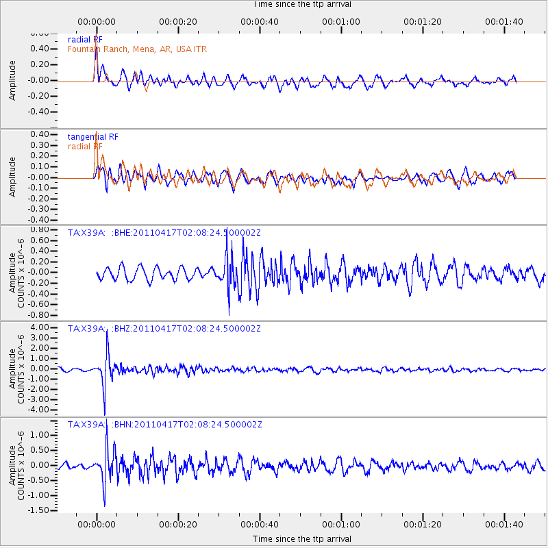
X39A Fountain Ranch, Mena, AR, USA - Earthquake Result Viewer
*The percent match for this event was below the threshold and hence no stack was calculated.
| Earthquake location: |
Santiago Del Estero Prov., Arg. |
| Earthquake latitude/longitude: |
-27.6/-63.2 |
| Earthquake time(UTC): |
2011/04/17 (107) 01:58:49 GMT |
| Earthquake Depth: |
557 km |
| Earthquake Magnitude: |
5.6 MB, 5.9 MW, 5.8 MW |
| Earthquake Catalog/Contributor: |
WHDF/NEIC |
|
| Network: |
TA USArray Transportable Network (new EarthScope stations) |
| Station: |
X39A Fountain Ranch, Mena, AR, USA |
| Lat/Lon: |
34.51 N/94.11 W |
| Elevation: |
326 m |
|
| Distance: |
68.4 deg |
| Az: |
332.843 deg |
| Baz: |
150.624 deg |
| Ray Param: |
$rayparam |
*The percent match for this event was below the threshold and hence was not used in the summary stack. |
|
| Radial Match: |
66.94194 % |
| Radial Bump: |
400 |
| Transverse Match: |
69.27784 % |
| Transverse Bump: |
400 |
| SOD ConfigId: |
356183 |
| Insert Time: |
2011-09-30 11:50:41.061 +0000 |
| GWidth: |
2.5 |
| Max Bumps: |
400 |
| Tol: |
0.001 |
|
Signal To Noise
| Channel | StoN | STA | LTA |
| TA:X39A: :BHZ:20110417T02:08:24.500002Z | 10.073272 | 1.4073559E-6 | 1.397119E-7 |
| TA:X39A: :BHN:20110417T02:08:24.500002Z | 4.75053 | 5.3577287E-7 | 1.1278171E-7 |
| TA:X39A: :BHE:20110417T02:08:24.500002Z | 2.5629761 | 2.8168134E-7 | 1.0990399E-7 |
| Arrivals |
| Ps | |
| PpPs | |
| PsPs/PpSs | |


