You are here: Home > Network List > TA - USArray Transportable Network (new EarthScope stations) Stations List
> Station 144A alexander Place, Bentonia, MS, USA > Earthquake Result Viewer
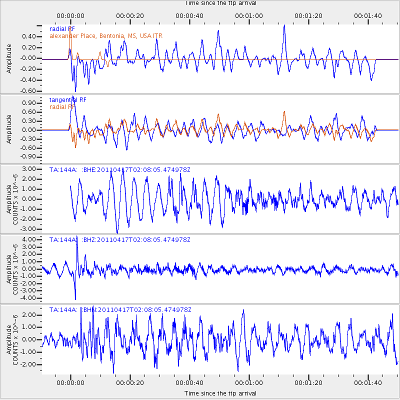
144A alexander Place, Bentonia, MS, USA - Earthquake Result Viewer
*The percent match for this event was below the threshold and hence no stack was calculated.
| Earthquake location: |
Santiago Del Estero Prov., Arg. |
| Earthquake latitude/longitude: |
-27.6/-63.2 |
| Earthquake time(UTC): |
2011/04/17 (107) 01:58:49 GMT |
| Earthquake Depth: |
557 km |
| Earthquake Magnitude: |
5.6 MB, 5.9 MW, 5.8 MW |
| Earthquake Catalog/Contributor: |
WHDF/NEIC |
|
| Network: |
TA USArray Transportable Network (new EarthScope stations) |
| Station: |
144A alexander Place, Bentonia, MS, USA |
| Lat/Lon: |
32.63 N/90.42 W |
| Elevation: |
78 m |
|
| Distance: |
65.3 deg |
| Az: |
334.848 deg |
| Baz: |
153.446 deg |
| Ray Param: |
$rayparam |
*The percent match for this event was below the threshold and hence was not used in the summary stack. |
|
| Radial Match: |
67.832436 % |
| Radial Bump: |
391 |
| Transverse Match: |
47.73411 % |
| Transverse Bump: |
400 |
| SOD ConfigId: |
356183 |
| Insert Time: |
2011-09-30 12:10:14.730 +0000 |
| GWidth: |
2.5 |
| Max Bumps: |
400 |
| Tol: |
0.001 |
|
Signal To Noise
| Channel | StoN | STA | LTA |
| TA:144A: :BHZ:20110417T02:08:05.474978Z | 4.5916047 | 1.5408506E-6 | 3.3557995E-7 |
| TA:144A: :BHN:20110417T02:08:05.474978Z | 0.8823776 | 7.3772367E-7 | 8.360634E-7 |
| TA:144A: :BHE:20110417T02:08:05.474978Z | 0.81516844 | 1.1752056E-6 | 1.4416721E-6 |
| Arrivals |
| Ps | |
| PpPs | |
| PsPs/PpSs | |


