You are here: Home > Network List > US - United States National Seismic Network Stations List
> Station TPNV Topopah Spring, Nevada, USA > Earthquake Result Viewer
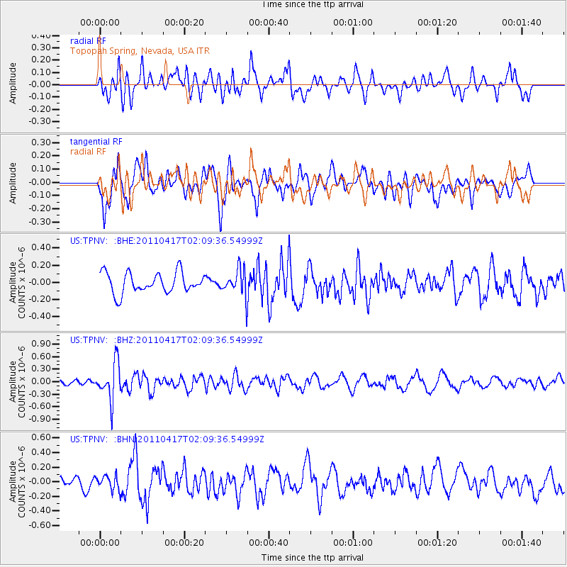
TPNV Topopah Spring, Nevada, USA - Earthquake Result Viewer
*The percent match for this event was below the threshold and hence no stack was calculated.
| Earthquake location: |
Santiago Del Estero Prov., Arg. |
| Earthquake latitude/longitude: |
-27.6/-63.2 |
| Earthquake time(UTC): |
2011/04/17 (107) 01:58:49 GMT |
| Earthquake Depth: |
557 km |
| Earthquake Magnitude: |
5.6 MB, 5.9 MW, 5.8 MW |
| Earthquake Catalog/Contributor: |
WHDF/NEIC |
|
| Network: |
US United States National Seismic Network |
| Station: |
TPNV Topopah Spring, Nevada, USA |
| Lat/Lon: |
36.95 N/116.25 W |
| Elevation: |
1600 m |
|
| Distance: |
81.3 deg |
| Az: |
319.633 deg |
| Baz: |
134.148 deg |
| Ray Param: |
$rayparam |
*The percent match for this event was below the threshold and hence was not used in the summary stack. |
|
| Radial Match: |
63.256756 % |
| Radial Bump: |
400 |
| Transverse Match: |
70.39833 % |
| Transverse Bump: |
400 |
| SOD ConfigId: |
356183 |
| Insert Time: |
2011-09-30 12:21:16.798 +0000 |
| GWidth: |
2.5 |
| Max Bumps: |
400 |
| Tol: |
0.001 |
|
Signal To Noise
| Channel | StoN | STA | LTA |
| US:TPNV: :BHZ:20110417T02:09:36.54999Z | 5.2569604 | 4.5265617E-7 | 8.610606E-8 |
| US:TPNV: :BHN:20110417T02:09:36.54999Z | 1.4241894 | 9.561059E-8 | 6.7133335E-8 |
| US:TPNV: :BHE:20110417T02:09:36.54999Z | 1.3378154 | 1.5792887E-7 | 1.18049826E-7 |
| Arrivals |
| Ps | |
| PpPs | |
| PsPs/PpSs | |


