You are here: Home > Network List > AZ - ANZA Regional Network Stations List
> Station SND AZ.SND > Earthquake Result Viewer
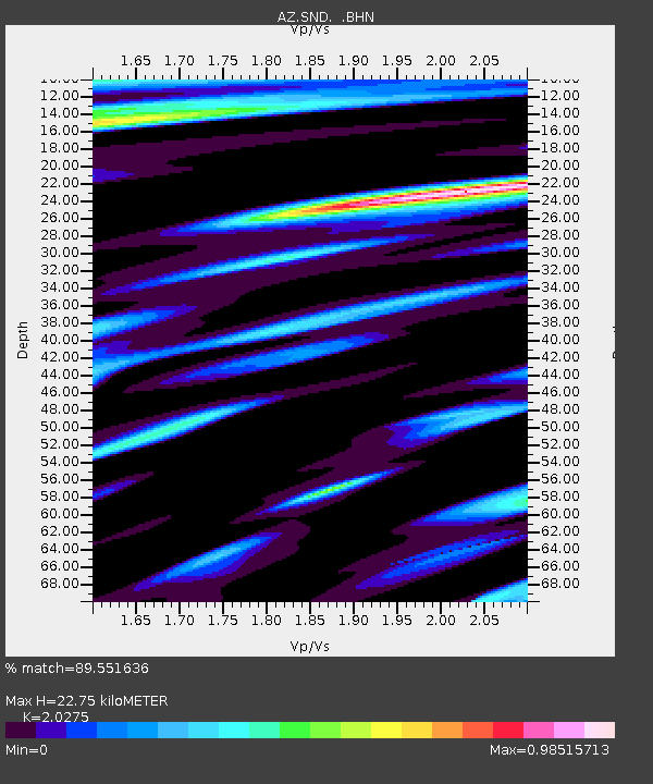
SND AZ.SND - Earthquake Result Viewer
| Earthquake location: |
Northern Peru |
| Earthquake latitude/longitude: |
-3.9/-77.0 |
| Earthquake time(UTC): |
1995/05/02 (122) 06:06:05 GMT |
| Earthquake Depth: |
103 km |
| Earthquake Magnitude: |
6.5 MB, 6.7 UNKNOWN, 6.6 MW |
| Earthquake Catalog/Contributor: |
WHDF/NEIC |
|
| Network: |
AZ ANZA Regional Network |
| Station: |
SND AZ.SND |
| Lat/Lon: |
33.55 N/116.61 W |
| Elevation: |
1358 m |
|
| Distance: |
52.8 deg |
| Az: |
317.997 deg |
| Baz: |
126.915 deg |
| Ray Param: |
0.06620261 |
| Estimated Moho Depth: |
22.75 km |
| Estimated Crust Vp/Vs: |
2.03 |
| Assumed Crust Vp: |
6.264 km/s |
| Estimated Crust Vs: |
3.089 km/s |
| Estimated Crust Poisson's Ratio: |
0.34 |
|
| Radial Match: |
89.551636 % |
| Radial Bump: |
400 |
| Transverse Match: |
81.90743 % |
| Transverse Bump: |
400 |
| SOD ConfigId: |
6273 |
| Insert Time: |
2010-02-26 20:51:44.944 +0000 |
| GWidth: |
2.5 |
| Max Bumps: |
400 |
| Tol: |
0.001 |
|

Signal To Noise
| Channel | StoN | STA | LTA |
| AZ:SND: :BHN:19950502T06:14:39.925024Z | 3.405796 | 1.2796118E-6 | 3.757159E-7 |
| AZ:SND: :BHE:19950502T06:14:39.925024Z | 9.710572 | 1.9829697E-6 | 2.042073E-7 |
| AZ:SND: :BHZ:19950502T06:14:39.925024Z | 10.278794 | 4.2567553E-6 | 4.1412983E-7 |
| Arrivals |
| Ps | 3.9 SECOND |
| PpPs | 11 SECOND |
| PsPs/PpSs | 14 SECOND |


