You are here: Home > Network List > AU - Australian Seismological Centre Stations List
> Station KMBL Kambalda, Western Australia > Earthquake Result Viewer
KMBL Kambalda, Western Australia - Earthquake Result Viewer
| Earthquake location: |
South Of Kermadec Islands |
| Earthquake latitude/longitude: |
-34.3/179.9 |
| Earthquake time(UTC): |
2011/04/18 (108) 13:03:02 GMT |
| Earthquake Depth: |
86 km |
| Earthquake Magnitude: |
6.2 MB, 6.6 MW, 6.5 MW |
| Earthquake Catalog/Contributor: |
WHDF/NEIC |
|
| Network: |
AU Australian Seismological Centre |
| Station: |
KMBL Kambalda, Western Australia |
| Lat/Lon: |
31.37 S/121.88 E |
| Elevation: |
370 m |
|
| Distance: |
48.2 deg |
| Az: |
256.506 deg |
| Baz: |
109.833 deg |
| Ray Param: |
0.069211565 |
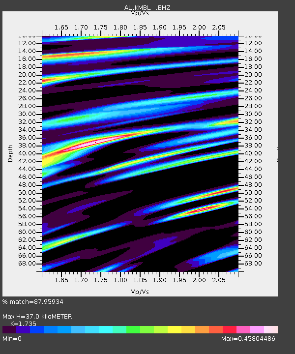
| Estimated Moho Depth: |
37.0 km |
| Estimated Crust Vp/Vs: |
1.74 |
| Assumed Crust Vp: |
6.459 km/s |
| Estimated Crust Vs: |
3.723 km/s |
| Estimated Crust Poisson's Ratio: |
0.25 |
|
| Radial Match: |
87.95934 % |
| Radial Bump: |
400 |
| Transverse Match: |
66.56163 % |
| Transverse Bump: |
400 |
| SOD ConfigId: |
356183 |
| Insert Time: |
2011-09-30 12:38:59.518 +0000 |
| GWidth: |
2.5 |
| Max Bumps: |
400 |
| Tol: |
0.001 |
|

Signal To Noise
| Channel | StoN | STA | LTA |
| AU:KMBL: :BHZ:20110418T13:11:04.370015Z | 3.6586037 | 1.6992867E-6 | 4.644632E-7 |
| AU:KMBL: :BHN:20110418T13:11:04.370015Z | 1.1788831 | 3.34296E-7 | 2.8357013E-7 |
| AU:KMBL: :BHE:20110418T13:11:04.370015Z | 4.0879908 | 1.0096372E-6 | 2.4697638E-7 |
| Arrivals |
| Ps | 4.5 SECOND |
| PpPs | 15 SECOND |
| PsPs/PpSs | 19 SECOND |


