You are here: Home > Network List > AZ - ANZA Regional Network Stations List
> Station SOL AZ.SOL > Earthquake Result Viewer
SOL AZ.SOL - Earthquake Result Viewer
| Earthquake location: |
South Of Kermadec Islands |
| Earthquake latitude/longitude: |
-34.3/179.9 |
| Earthquake time(UTC): |
2011/04/18 (108) 13:03:02 GMT |
| Earthquake Depth: |
86 km |
| Earthquake Magnitude: |
6.2 MB, 6.6 MW, 6.5 MW |
| Earthquake Catalog/Contributor: |
WHDF/NEIC |
|
| Network: |
AZ ANZA Regional Network |
| Station: |
SOL AZ.SOL |
| Lat/Lon: |
32.84 N/117.25 W |
| Elevation: |
245 m |
|
| Distance: |
89.2 deg |
| Az: |
48.533 deg |
| Baz: |
227.441 deg |
| Ray Param: |
0.0418809 |
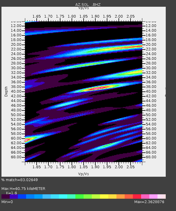
| Estimated Moho Depth: |
60.75 km |
| Estimated Crust Vp/Vs: |
1.60 |
| Assumed Crust Vp: |
6.264 km/s |
| Estimated Crust Vs: |
3.915 km/s |
| Estimated Crust Poisson's Ratio: |
0.18 |
|
| Radial Match: |
83.02649 % |
| Radial Bump: |
400 |
| Transverse Match: |
74.65153 % |
| Transverse Bump: |
400 |
| SOD ConfigId: |
356183 |
| Insert Time: |
2011-09-30 12:45:23.678 +0000 |
| GWidth: |
2.5 |
| Max Bumps: |
400 |
| Tol: |
0.001 |
|

Signal To Noise
| Channel | StoN | STA | LTA |
| AZ:SOL: :BHZ:20110418T13:15:17.574971Z | 4.952206 | 1.6627098E-6 | 3.357513E-7 |
| AZ:SOL: :BHN:20110418T13:15:17.574971Z | 1.1557958 | 7.21188E-7 | 6.239752E-7 |
| AZ:SOL: :BHE:20110418T13:15:17.574971Z | 1.4023719 | 7.1130165E-7 | 5.0721326E-7 |
| Arrivals |
| Ps | 5.9 SECOND |
| PpPs | 25 SECOND |
| PsPs/PpSs | 31 SECOND |


