You are here: Home > Network List > G - GEOSCOPE Stations List
> Station PPTF Pamatai - Papeete - Tahiti island - French Polynesia, France > Earthquake Result Viewer
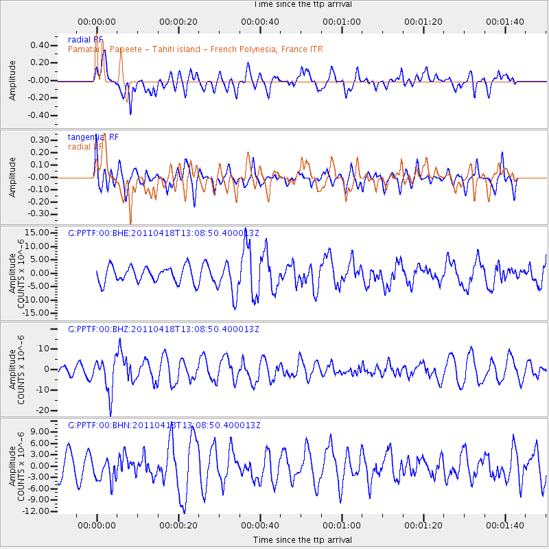
PPTF Pamatai - Papeete - Tahiti island - French Polynesia, France - Earthquake Result Viewer
*The percent match for this event was below the threshold and hence no stack was calculated.
| Earthquake location: |
South Of Kermadec Islands |
| Earthquake latitude/longitude: |
-34.3/179.9 |
| Earthquake time(UTC): |
2011/04/18 (108) 13:03:02 GMT |
| Earthquake Depth: |
86 km |
| Earthquake Magnitude: |
6.2 MB, 6.6 MW, 6.5 MW |
| Earthquake Catalog/Contributor: |
WHDF/NEIC |
|
| Network: |
G GEOSCOPE |
| Station: |
PPTF Pamatai - Papeete - Tahiti island - French Polynesia, France |
| Lat/Lon: |
17.59 S/149.57 W |
| Elevation: |
705 m |
|
| Distance: |
32.0 deg |
| Az: |
66.329 deg |
| Baz: |
232.614 deg |
| Ray Param: |
$rayparam |
*The percent match for this event was below the threshold and hence was not used in the summary stack. |
|
| Radial Match: |
41.39438 % |
| Radial Bump: |
400 |
| Transverse Match: |
55.01227 % |
| Transverse Bump: |
400 |
| SOD ConfigId: |
356183 |
| Insert Time: |
2011-09-30 13:02:29.668 +0000 |
| GWidth: |
2.5 |
| Max Bumps: |
400 |
| Tol: |
0.001 |
|
Signal To Noise
| Channel | StoN | STA | LTA |
| G:PPTF:00:BHZ:20110418T13:08:50.400013Z | 2.6807137 | 8.373369E-6 | 3.1235597E-6 |
| G:PPTF:00:BHN:20110418T13:08:50.400013Z | 0.58532375 | 3.1107777E-6 | 5.3146273E-6 |
| G:PPTF:00:BHE:20110418T13:08:50.400013Z | 2.071301 | 6.070911E-6 | 2.9309651E-6 |
| Arrivals |
| Ps | |
| PpPs | |
| PsPs/PpSs | |


