You are here: Home > Network List > AK - Alaska Regional Network Stations List
> Station MDM Murphy Dome > Earthquake Result Viewer
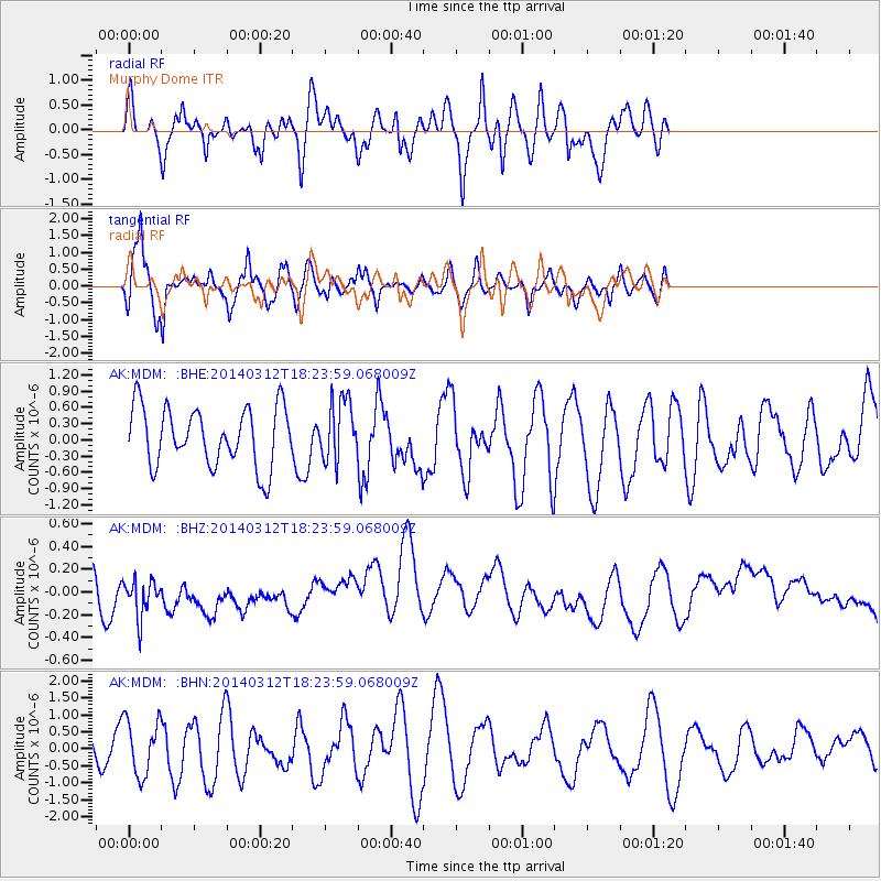
MDM Murphy Dome - Earthquake Result Viewer
*The percent match for this event was below the threshold and hence no stack was calculated.
| Earthquake location: |
Northwest Of Kuril Islands |
| Earthquake latitude/longitude: |
52.0/153.2 |
| Earthquake time(UTC): |
2014/03/12 (071) 18:18:40 GMT |
| Earthquake Depth: |
418 km |
| Earthquake Magnitude: |
5.1 MW |
| Earthquake Catalog/Contributor: |
ISC/ISC |
|
| Network: |
AK Alaska Regional Network |
| Station: |
MDM Murphy Dome |
| Lat/Lon: |
64.96 N/148.23 W |
| Elevation: |
634 m |
|
| Distance: |
32.0 deg |
| Az: |
43.339 deg |
| Baz: |
274.658 deg |
| Ray Param: |
$rayparam |
*The percent match for this event was below the threshold and hence was not used in the summary stack. |
|
| Radial Match: |
59.163635 % |
| Radial Bump: |
400 |
| Transverse Match: |
73.81702 % |
| Transverse Bump: |
400 |
| SOD ConfigId: |
3390531 |
| Insert Time: |
2019-04-10 14:43:26.401 +0000 |
| GWidth: |
2.5 |
| Max Bumps: |
400 |
| Tol: |
0.001 |
|
Signal To Noise
| Channel | StoN | STA | LTA |
| AK:MDM: :BHZ:20140312T18:23:59.068009Z | 1.1400883 | 1.9404327E-7 | 1.7020021E-7 |
| AK:MDM: :BHN:20140312T18:23:59.068009Z | 1.3116941 | 8.1780024E-7 | 6.2346874E-7 |
| AK:MDM: :BHE:20140312T18:23:59.068009Z | 1.0227166 | 5.5681994E-7 | 5.4445184E-7 |
| Arrivals |
| Ps | |
| PpPs | |
| PsPs/PpSs | |


