You are here: Home > Network List > TA - USArray Transportable Network (new EarthScope stations) Stations List
> Station 109C Camp Elliot, Mirimar, CA, USA > Earthquake Result Viewer
109C Camp Elliot, Mirimar, CA, USA - Earthquake Result Viewer
| Earthquake location: |
South Of Kermadec Islands |
| Earthquake latitude/longitude: |
-34.3/179.9 |
| Earthquake time(UTC): |
2011/04/18 (108) 13:03:02 GMT |
| Earthquake Depth: |
86 km |
| Earthquake Magnitude: |
6.2 MB, 6.6 MW, 6.5 MW |
| Earthquake Catalog/Contributor: |
WHDF/NEIC |
|
| Network: |
TA USArray Transportable Network (new EarthScope stations) |
| Station: |
109C Camp Elliot, Mirimar, CA, USA |
| Lat/Lon: |
32.89 N/117.11 W |
| Elevation: |
150 m |
|
| Distance: |
89.3 deg |
| Az: |
48.579 deg |
| Baz: |
227.519 deg |
| Ray Param: |
0.041793127 |
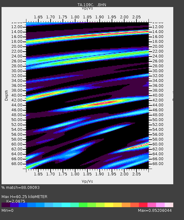
| Estimated Moho Depth: |
60.25 km |
| Estimated Crust Vp/Vs: |
2.07 |
| Assumed Crust Vp: |
6.264 km/s |
| Estimated Crust Vs: |
3.03 km/s |
| Estimated Crust Poisson's Ratio: |
0.35 |
|
| Radial Match: |
88.09093 % |
| Radial Bump: |
400 |
| Transverse Match: |
69.42031 % |
| Transverse Bump: |
400 |
| SOD ConfigId: |
356183 |
| Insert Time: |
2011-09-30 13:07:19.917 +0000 |
| GWidth: |
2.5 |
| Max Bumps: |
400 |
| Tol: |
0.001 |
|

Signal To Noise
| Channel | StoN | STA | LTA |
| TA:109C: :BHZ:20110418T13:15:18.144978Z | 4.108072 | 1.2375884E-6 | 3.0125773E-7 |
| TA:109C: :BHN:20110418T13:15:18.144978Z | 1.1549942 | 2.8691937E-7 | 2.4841628E-7 |
| TA:109C: :BHE:20110418T13:15:18.144978Z | 2.2441638 | 3.017525E-7 | 1.3446099E-7 |
| Arrivals |
| Ps | 10 SECOND |
| PpPs | 29 SECOND |
| PsPs/PpSs | 39 SECOND |


