You are here: Home > Network List > TA - USArray Transportable Network (new EarthScope stations) Stations List
> Station I04A Tendick Farm, Oakridge, OR, USA > Earthquake Result Viewer
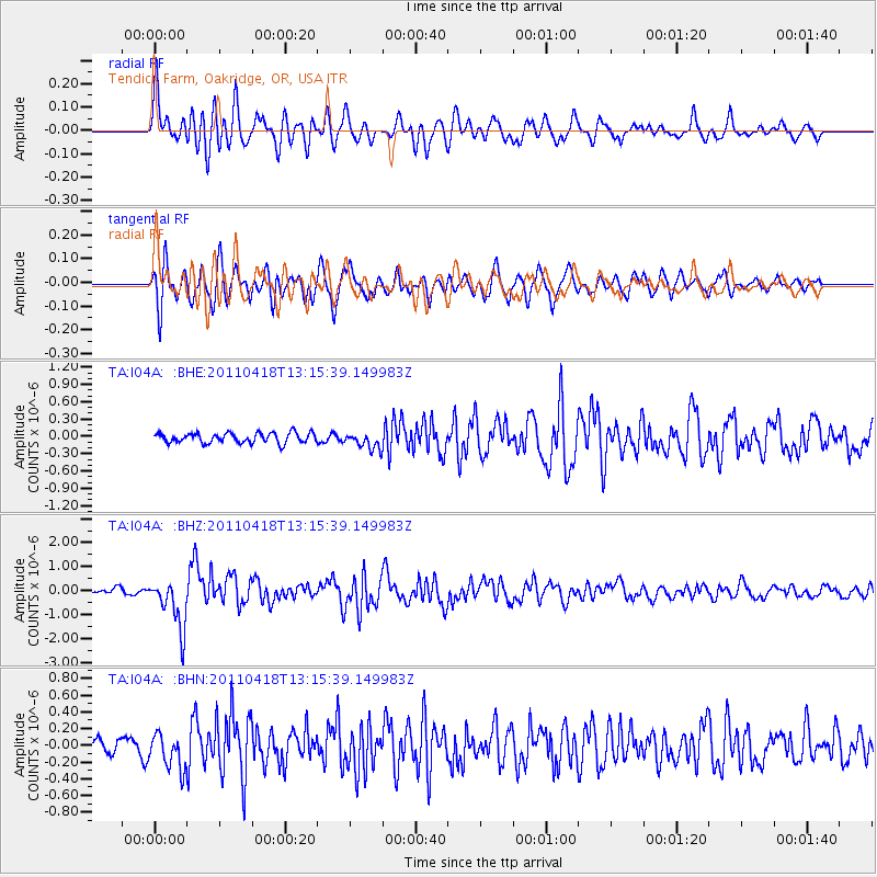
I04A Tendick Farm, Oakridge, OR, USA - Earthquake Result Viewer

| Earthquake location: |
South Of Kermadec Islands |
| Earthquake latitude/longitude: |
-34.3/179.9 |
| Earthquake time(UTC): |
2011/04/18 (108) 13:03:02 GMT |
| Earthquake Depth: |
86 km |
| Earthquake Magnitude: |
6.2 MB, 6.6 MW, 6.5 MW |
| Earthquake Catalog/Contributor: |
WHDF/NEIC |
|
| Network: |
TA USArray Transportable Network (new EarthScope stations) |
| Station: |
I04A Tendick Farm, Oakridge, OR, USA |
| Lat/Lon: |
43.79 N/122.41 W |
| Elevation: |
731 m |
|
| Distance: |
93.8 deg |
| Az: |
37.849 deg |
| Baz: |
224.519 deg |
| Ray Param: |
0.04112879 |
| Estimated Moho Depth: |
63.0 km |
| Estimated Crust Vp/Vs: |
2.09 |
| Assumed Crust Vp: |
6.522 km/s |
| Estimated Crust Vs: |
3.117 km/s |
| Estimated Crust Poisson's Ratio: |
0.35 |
|
| Radial Match: |
82.44741 % |
| Radial Bump: |
400 |
| Transverse Match: |
80.15496 % |
| Transverse Bump: |
400 |
| SOD ConfigId: |
356183 |
| Insert Time: |
2011-09-30 13:08:22.806 +0000 |
| GWidth: |
2.5 |
| Max Bumps: |
400 |
| Tol: |
0.001 |
|
Signal To Noise
| Channel | StoN | STA | LTA |
| TA:I04A: :BHZ:20110418T13:15:39.149983Z | 9.732777 | 1.0477604E-6 | 1.0765278E-7 |
| TA:I04A: :BHN:20110418T13:15:39.149983Z | 1.6068878 | 2.1475265E-7 | 1.3364507E-7 |
| TA:I04A: :BHE:20110418T13:15:39.149983Z | 1.6765133 | 1.4197961E-7 | 8.4687436E-8 |
| Arrivals |
| Ps | 11 SECOND |
| PpPs | 29 SECOND |
| PsPs/PpSs | 40 SECOND |


