You are here: Home > Network List > TA - USArray Transportable Network (new EarthScope stations) Stations List
> Station O03D Paynes Creek, CA, USA > Earthquake Result Viewer
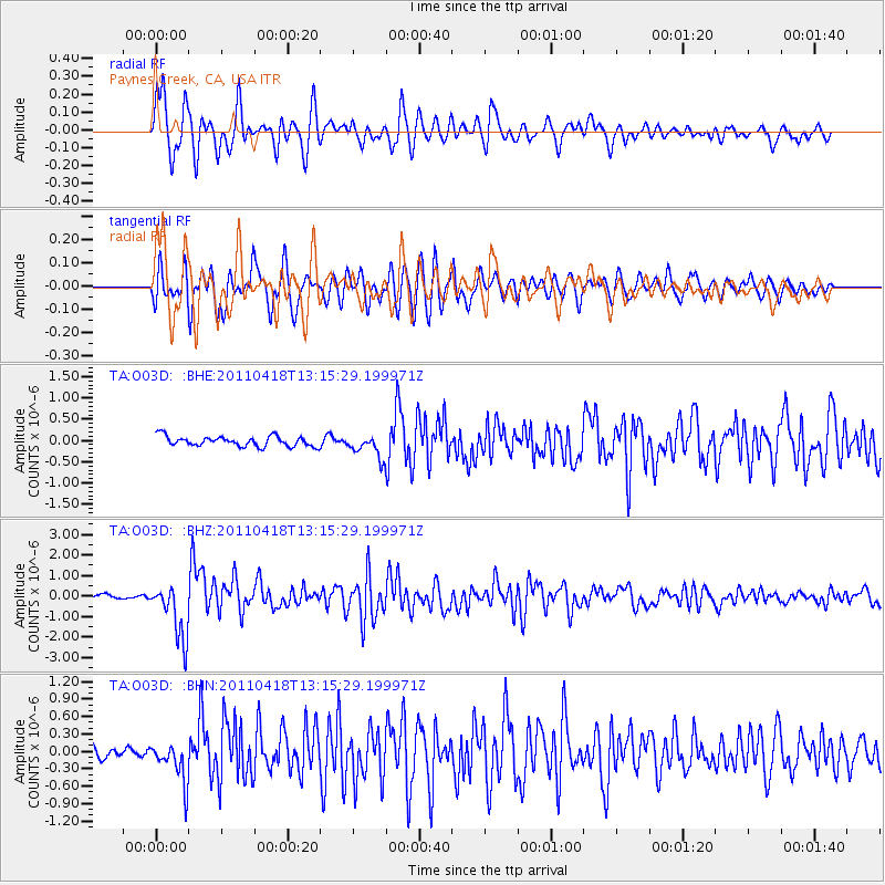
O03D Paynes Creek, CA, USA - Earthquake Result Viewer
*The percent match for this event was below the threshold and hence no stack was calculated.
| Earthquake location: |
South Of Kermadec Islands |
| Earthquake latitude/longitude: |
-34.3/179.9 |
| Earthquake time(UTC): |
2011/04/18 (108) 13:03:02 GMT |
| Earthquake Depth: |
86 km |
| Earthquake Magnitude: |
6.2 MB, 6.6 MW, 6.5 MW |
| Earthquake Catalog/Contributor: |
WHDF/NEIC |
|
| Network: |
TA USArray Transportable Network (new EarthScope stations) |
| Station: |
O03D Paynes Creek, CA, USA |
| Lat/Lon: |
40.29 N/121.80 W |
| Elevation: |
968 m |
|
| Distance: |
91.7 deg |
| Az: |
40.633 deg |
| Baz: |
224.792 deg |
| Ray Param: |
$rayparam |
*The percent match for this event was below the threshold and hence was not used in the summary stack. |
|
| Radial Match: |
87.83614 % |
| Radial Bump: |
400 |
| Transverse Match: |
82.388214 % |
| Transverse Bump: |
400 |
| SOD ConfigId: |
356183 |
| Insert Time: |
2011-09-30 13:12:32.732 +0000 |
| GWidth: |
2.5 |
| Max Bumps: |
400 |
| Tol: |
0.001 |
|
Signal To Noise
| Channel | StoN | STA | LTA |
| TA:O03D: :BHZ:20110418T13:15:29.199971Z | 15.154017 | 1.3688908E-6 | 9.033187E-8 |
| TA:O03D: :BHN:20110418T13:15:29.199971Z | 3.2546182 | 3.4650617E-7 | 1.06466E-7 |
| TA:O03D: :BHE:20110418T13:15:29.199971Z | 2.3071454 | 2.7224564E-7 | 1.1800108E-7 |
| Arrivals |
| Ps | |
| PpPs | |
| PsPs/PpSs | |


