You are here: Home > Network List > TA - USArray Transportable Network (new EarthScope stations) Stations List
> Station H04D Lebanon, OR, USA > Earthquake Result Viewer
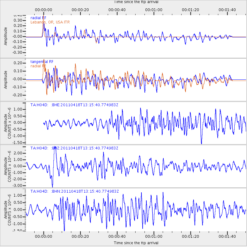
H04D Lebanon, OR, USA - Earthquake Result Viewer
*The percent match for this event was below the threshold and hence no stack was calculated.
| Earthquake location: |
South Of Kermadec Islands |
| Earthquake latitude/longitude: |
-34.3/179.9 |
| Earthquake time(UTC): |
2011/04/18 (108) 13:03:02 GMT |
| Earthquake Depth: |
86 km |
| Earthquake Magnitude: |
6.2 MB, 6.6 MW, 6.5 MW |
| Earthquake Catalog/Contributor: |
WHDF/NEIC |
|
| Network: |
TA USArray Transportable Network (new EarthScope stations) |
| Station: |
H04D Lebanon, OR, USA |
| Lat/Lon: |
44.52 N/122.74 W |
| Elevation: |
284 m |
|
| Distance: |
94.2 deg |
| Az: |
37.169 deg |
| Baz: |
224.341 deg |
| Ray Param: |
$rayparam |
*The percent match for this event was below the threshold and hence was not used in the summary stack. |
|
| Radial Match: |
71.60942 % |
| Radial Bump: |
400 |
| Transverse Match: |
76.977196 % |
| Transverse Bump: |
400 |
| SOD ConfigId: |
356183 |
| Insert Time: |
2011-09-30 13:13:12.073 +0000 |
| GWidth: |
2.5 |
| Max Bumps: |
400 |
| Tol: |
0.001 |
|
Signal To Noise
| Channel | StoN | STA | LTA |
| TA:H04D: :BHZ:20110418T13:15:40.774983Z | 4.1866083 | 1.0544504E-6 | 2.518627E-7 |
| TA:H04D: :BHN:20110418T13:15:40.774983Z | 0.8752672 | 2.4066458E-7 | 2.7496125E-7 |
| TA:H04D: :BHE:20110418T13:15:40.774983Z | 1.639724 | 2.8253882E-7 | 1.7230877E-7 |
| Arrivals |
| Ps | |
| PpPs | |
| PsPs/PpSs | |


