You are here: Home > Network List > N4 - Central and EAstern US Network Stations List
> Station W50A Signal Mountain, TN, USA > Earthquake Result Viewer
W50A Signal Mountain, TN, USA - Earthquake Result Viewer
| Earthquake location: |
Northwest Of Kuril Islands |
| Earthquake latitude/longitude: |
52.0/153.2 |
| Earthquake time(UTC): |
2014/03/12 (071) 18:18:40 GMT |
| Earthquake Depth: |
418 km |
| Earthquake Magnitude: |
5.1 MW |
| Earthquake Catalog/Contributor: |
ISC/ISC |
|
| Network: |
N4 Central and EAstern US Network |
| Station: |
W50A Signal Mountain, TN, USA |
| Lat/Lon: |
35.20 N/85.31 W |
| Elevation: |
587 m |
|
| Distance: |
79.2 deg |
| Az: |
45.302 deg |
| Baz: |
327.556 deg |
| Ray Param: |
0.0479176 |
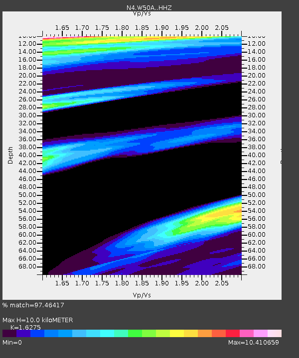
| Estimated Moho Depth: |
10.0 km |
| Estimated Crust Vp/Vs: |
1.63 |
| Assumed Crust Vp: |
6.35 km/s |
| Estimated Crust Vs: |
3.902 km/s |
| Estimated Crust Poisson's Ratio: |
0.20 |
|
| Radial Match: |
97.46417 % |
| Radial Bump: |
272 |
| Transverse Match: |
97.65972 % |
| Transverse Bump: |
261 |
| SOD ConfigId: |
3390531 |
| Insert Time: |
2019-04-10 14:46:59.900 +0000 |
| GWidth: |
2.5 |
| Max Bumps: |
400 |
| Tol: |
0.001 |
|

Signal To Noise
| Channel | StoN | STA | LTA |
| N4:W50A: :HHZ:20140312T18:29:29.390Z | 13.175104 | 9.636027E-4 | 7.3138144E-5 |
| N4:W50A: :HHN:20140312T18:29:29.390Z | 8.66625 | 0.006757347 | 7.797314E-4 |
| N4:W50A: :HHE:20140312T18:29:29.390Z | 8.451971 | 0.0077198506 | 9.133788E-4 |
| Arrivals |
| Ps | 1.0 SECOND |
| PpPs | 4.0 SECOND |
| PsPs/PpSs | 5.0 SECOND |


