You are here: Home > Network List > CN - Canadian National Seismograph Network Stations List
> Station INK INUVIK, NT, CANADA.ANADA > Earthquake Result Viewer
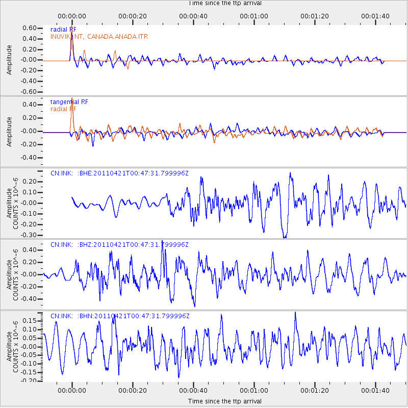
INK INUVIK, NT, CANADA.ANADA - Earthquake Result Viewer
*The percent match for this event was below the threshold and hence no stack was calculated.
| Earthquake location: |
Off East Coast Of Honshu, Japan |
| Earthquake latitude/longitude: |
40.3/143.5 |
| Earthquake time(UTC): |
2011/04/21 (111) 00:39:03 GMT |
| Earthquake Depth: |
10 km |
| Earthquake Magnitude: |
5.7 MW, 5.2 MS, 5.4 MB, 5.6 MW |
| Earthquake Catalog/Contributor: |
WHDF/NEIC |
|
| Network: |
CN Canadian National Seismograph Network |
| Station: |
INK INUVIK, NT, CANADA.ANADA |
| Lat/Lon: |
68.31 N/133.52 W |
| Elevation: |
40 m |
|
| Distance: |
50.7 deg |
| Az: |
28.482 deg |
| Baz: |
281.361 deg |
| Ray Param: |
$rayparam |
*The percent match for this event was below the threshold and hence was not used in the summary stack. |
|
| Radial Match: |
71.49041 % |
| Radial Bump: |
400 |
| Transverse Match: |
45.09549 % |
| Transverse Bump: |
400 |
| SOD ConfigId: |
356183 |
| Insert Time: |
2011-09-30 13:39:07.481 +0000 |
| GWidth: |
2.5 |
| Max Bumps: |
400 |
| Tol: |
0.001 |
|
Signal To Noise
| Channel | StoN | STA | LTA |
| CN:INK: :BHZ:20110421T00:47:31.799996Z | 3.0270457 | 1.3124597E-7 | 4.3357776E-8 |
| CN:INK: :BHN:20110421T00:47:31.799996Z | 1.3249732 | 6.683902E-8 | 5.0445568E-8 |
| CN:INK: :BHE:20110421T00:47:31.799996Z | 1.5558349 | 6.266811E-8 | 4.0279406E-8 |
| Arrivals |
| Ps | |
| PpPs | |
| PsPs/PpSs | |


