You are here: Home > Network List > TA - USArray Transportable Network (new EarthScope stations) Stations List
> Station D46A Sault St. Marie, ON, CAN > Earthquake Result Viewer
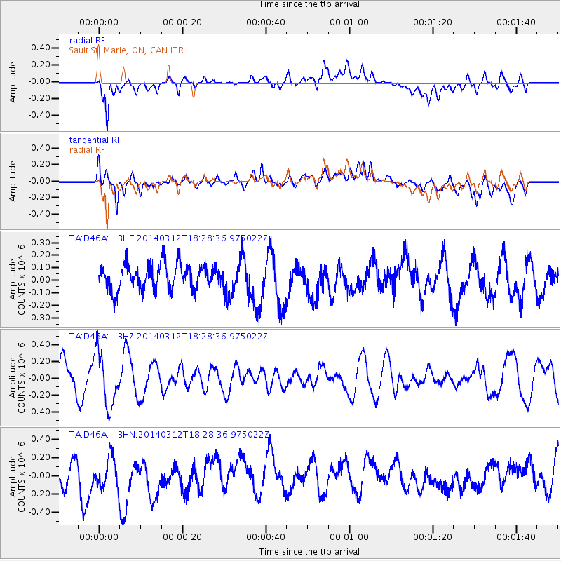
D46A Sault St. Marie, ON, CAN - Earthquake Result Viewer
*The percent match for this event was below the threshold and hence no stack was calculated.
| Earthquake location: |
Northwest Of Kuril Islands |
| Earthquake latitude/longitude: |
52.0/153.2 |
| Earthquake time(UTC): |
2014/03/12 (071) 18:18:40 GMT |
| Earthquake Depth: |
418 km |
| Earthquake Magnitude: |
5.1 MW |
| Earthquake Catalog/Contributor: |
ISC/ISC |
|
| Network: |
TA USArray Transportable Network (new EarthScope stations) |
| Station: |
D46A Sault St. Marie, ON, CAN |
| Lat/Lon: |
46.89 N/84.04 W |
| Elevation: |
353 m |
|
| Distance: |
70.0 deg |
| Az: |
37.868 deg |
| Baz: |
326.412 deg |
| Ray Param: |
$rayparam |
*The percent match for this event was below the threshold and hence was not used in the summary stack. |
|
| Radial Match: |
57.36262 % |
| Radial Bump: |
400 |
| Transverse Match: |
54.265747 % |
| Transverse Bump: |
400 |
| SOD ConfigId: |
3390531 |
| Insert Time: |
2019-04-10 14:48:25.539 +0000 |
| GWidth: |
2.5 |
| Max Bumps: |
400 |
| Tol: |
0.001 |
|
Signal To Noise
| Channel | StoN | STA | LTA |
| TA:D46A: :BHZ:20140312T18:28:36.975022Z | 1.888617 | 3.203263E-7 | 1.6960892E-7 |
| TA:D46A: :BHN:20140312T18:28:36.975022Z | 1.0698336 | 1.8371274E-7 | 1.7172084E-7 |
| TA:D46A: :BHE:20140312T18:28:36.975022Z | 1.3640215 | 1.4373937E-7 | 1.053791E-7 |
| Arrivals |
| Ps | |
| PpPs | |
| PsPs/PpSs | |


